 vesseltracker.com
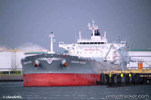
 AMAZON VICTORY
Current Status
Where is the vessel?
AMAZON VICTORY is currently in 11 nm S of Guarujá, based on AIS data received about 1h ago.
Latest AIS update:
Current position: 24.18301° S, 46.18840° W (11 nm S of Guarujá)
Average speed (last 7 days): Loading…
Average speed (last 30 days): Loading…
Vessel profile: AMAZON VICTORY is a Tanker with dimensions m x m.
This page combines live AIS, route history, probable destination signals, nearby traffic, and port activity for practical vessel monitoring.
The current position of vessel AMAZON VICTORY is -24.18301 lat / -46.18840 lng. Updated: 2026-05-14 19:44:45 UTCNearest reference points:
- Near Guarujá
- Near Santos
- 30 nm SE of Guarujá
Currently sailing under the flag of Greece ![]()
Details:
Live Vessel AMAZON VICTORY Analytics (details, animations, etc.)
Recent AIS points (UTC):
2026-05-14 16:29:44 UTC · -24.18293, -46.18796 · SOG 0.1 kn · COG 200°2026-05-14 17:47:41 UTC · -24.18296, -46.18836 · SOG 0.1 kn · COG 190°
2026-05-14 19:26:41 UTC · -24.18295, -46.18814 · SOG 0.2 kn · COG 195°
2026-05-14 19:44:45 UTC · -24.18301, -46.18840 · SOG 0.1 kn · COG 191°