 vesseltracker.com
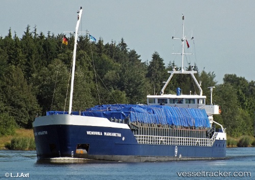
 Hendrika Margaretha
Current Status
Where is the vessel?
Hendrika Margaretha is currently in Near Molengat, based on AIS data received about 1h ago.
Latest AIS update:
Current position: 53.07266° N, 4.56285° E (Near Molengat)
Average speed (last 7 days): Loading…
Average speed (last 30 days): Loading…
Vessel profile: Hendrika Margaretha is a General Cargo Ship with dimensions 81m x 12m.
This page combines live AIS, route history, probable destination signals, nearby traffic, and port activity for practical vessel monitoring.
The current position of vessel Hendrika Margaretha is 53.07266 lat / 4.56285 lng. Updated: 2026-05-16 01:50:45 UTCNearest reference points:
- Near Molengat
- Near Den Helder
- Near de Waal
Currently sailing under the flag of Netherlands ![]()
Hendrika Margaretha built in 1993 year
Deadweight:
3200 tDetails:
Live Vessel Hendrika Margaretha Analytics (details, animations, etc.)
Recent AIS points (UTC):
2026-05-15 22:09:28 UTC · 53.42847, 4.61394 · SOG 6.6 kn · COG 198°2026-05-15 23:46:36 UTC · 53.25444, 4.50653 · SOG 6.8 kn · COG 195°
2026-05-16 01:28:06 UTC · 53.10712, 4.55811 · SOG 6 kn · COG 175°
2026-05-16 01:50:45 UTC · 53.07266, 4.56285 · SOG 4.7 kn · COG 196°