 vesseltracker.com
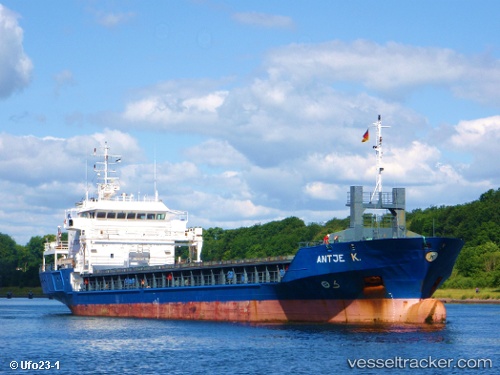
 Antje K
Current Status
Where is the vessel?
Antje K is currently in Near Ares, based on AIS data received about 1h ago.
Latest AIS update:
Current position: 43.38500° N, 8.24833° W (Near Ares)
Average speed (last 7 days): Loading…
Average speed (last 30 days): Loading…
Vessel profile: Antje K is a Multi Purpose Carrier with dimensions 90m x 15m.
This page combines live AIS, route history, probable destination signals, nearby traffic, and port activity for practical vessel monitoring.
The current position of vessel Antje K is 43.38500 lat / -8.24833 lng. Updated: 2026-05-14 16:34:27 UTCNearest reference points:
- Near Milladoiro
- Near Ferrol
- Near La Coruna
Currently sailing under the flag of Netherlands ![]()
Antje K built in 2002 year
Deadweight:
4247 tDetails:
Live Vessel Antje K Analytics (details, animations, etc.)
Recent AIS points (UTC):
2026-05-14 13:38:44 UTC · 43.38533, -8.24938 · SOG 0.1 kn · COG 323°2026-05-14 14:05:42 UTC · 43.38529, -8.24956 · SOG 0.1 kn · COG 333°
2026-05-14 15:38:49 UTC · 43.38533, -8.24935 · SOG 0.2 kn · COG 315°
2026-05-14 16:34:27 UTC · 43.38500, -8.24833 · SOG 0 kn · COG -1°