 vesseltracker.com
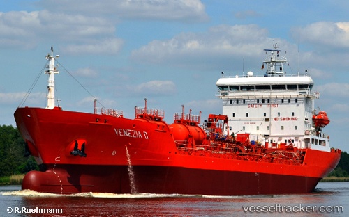
 Venezia D
Current Status
Where is the vessel?
Venezia D is currently in 46 nm NE of Utiel, based on AIS data received about 6h ago.
Latest AIS update:
Current position: 40.05667° N, 10.40167° W (46 nm NE of Utiel)
Average speed (last 7 days): Loading…
Average speed (last 30 days): Loading…
Vessel profile: Venezia D is a Chemical Oil Products Tanker with dimensions 126m x 19m.
This page combines live AIS, route history, probable destination signals, nearby traffic, and port activity for practical vessel monitoring.
The current position of vessel Venezia D is 40.05667 lat / -10.40167 lng. Updated: 2026-04-08 15:47:57 UTCNearest reference points:
- 52 nm W of Canas de Santa Maria
- 43 nm NW of Utiel
- Near PENICHE
Currently sailing under the flag of Netherlands ![]()
Venezia D built in 1998 year
Deadweight:
10127 tDetails:
Live Vessel Venezia D Analytics (details, animations, etc.)
Recent AIS points (UTC):
2026-04-08 14:11:58 UTC · 39.78667, -10.40667 · SOG 10 kn · COG -1°2026-04-08 15:47:57 UTC · 40.05667, -10.40167 · SOG 9 kn · COG -1°
2026-04-08 15:47:57 UTC · 40.05667, -10.40167 · SOG 9 kn · COG -1°
2026-04-08 15:47:57 UTC · 40.05667, -10.40167 · SOG 9 kn · COG -1°