 vesseltracker.com
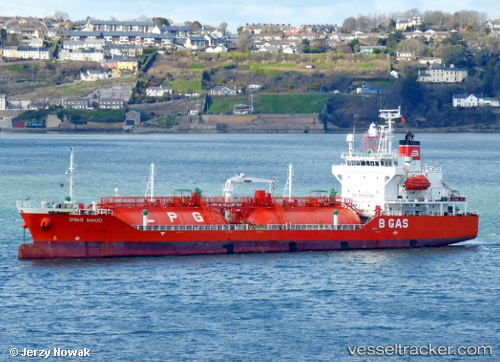
 B Gas Maud
Current Status
Where is the vessel?
B Gas Maud is currently in Near Saint-Martin-du-Manoir, based on AIS data received less than 1h ago.
Latest AIS update:
Current position: 49.58583° N, 0.21103° W (Near Saint-Martin-du-Manoir)
Average speed (last 7 days): Loading…
Average speed (last 30 days): Loading…
Vessel profile: B Gas Maud is a Lpg Tanker with dimensions 100m x 100m.
This page combines live AIS, route history, probable destination signals, nearby traffic, and port activity for practical vessel monitoring.
The current position of vessel B Gas Maud is 49.58583 lat / -0.21103 lng. Updated: 2026-05-15 01:10:53 UTCNearest reference points:
- Near Le Havre
- Near TROUVILLE-SUR-MER
- Near Caen
Currently sailing under the flag of Malta ![]()
B Gas Maud built in 2006 year
Deadweight:
5073 tDetails:
Live Vessel B Gas Maud Analytics (details, animations, etc.)
Recent AIS points (UTC):
2026-05-14 22:22:53 UTC · 49.58547, -0.21048 · SOG 0 kn · COG 44°2026-05-14 22:55:55 UTC · 49.58573, -0.21085 · SOG 0 kn · COG 66°
2026-05-14 23:46:55 UTC · 49.58587, -0.21098 · SOG 0 kn · COG 67°
2026-05-15 01:10:53 UTC · 49.58583, -0.21103 · SOG 0 kn · COG 58°