 vesseltracker.com
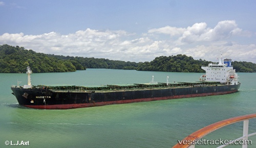
 Marietta
Current Status
Where is the vessel?
Marietta is currently in 55 nm E of Taytay Sandoval, based on AIS data received about 2h ago.
Latest AIS update:
Current position: 11.01731° N, 120.43517° E (55 nm E of Taytay Sandoval)
Average speed (last 7 days): Loading…
Average speed (last 30 days): Loading…
Vessel profile: Marietta is a Bulk Carrier with dimensions 225m x 32m.
This page combines live AIS, route history, probable destination signals, nearby traffic, and port activity for practical vessel monitoring.
The current position of vessel Marietta is 11.01731 lat / 120.43517 lng. Updated: 2026-05-14 14:02:32 UTCNearest reference points:
- 19 nm NE of CORON
- Near Iloilo
- 43 nm W of Malampaya
Currently sailing under the flag of Malta ![]()
Marietta built in 2004 year
Deadweight:
73880 tDetails:
Live Vessel Marietta Analytics (details, animations, etc.)
Recent AIS points (UTC):
2026-05-14 09:05:06 UTC · 10.13964, 120.39598 · SOG 10.9 kn · COG 2°2026-05-14 09:05:06 UTC · 10.13964, 120.39598 · SOG 10.9 kn · COG 2°
2026-05-14 14:02:32 UTC · 11.01731, 120.43517 · SOG 10.6 kn · COG 2°
2026-05-14 14:02:32 UTC · 11.01731, 120.43517 · SOG 10.6 kn · COG 2°