 vesseltracker.com
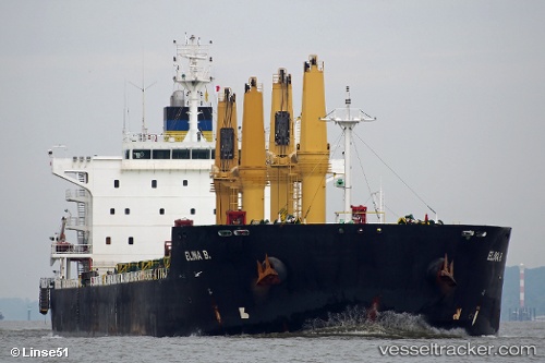
Elina B
Current StatusWhere is the vessel?
Elina B is currently in Near GEMLIK, based on AIS data received about 1d ago.
Latest AIS update:
Current position: 40.41725° N, 29.08472° E (Near GEMLIK)
Average speed (last 7 days): Loading…
Average speed (last 30 days): Loading…
Vessel profile: Elina B is a Bulk Carrier with dimensions 32m x 196m.
This page combines live AIS, route history, probable destination signals, nearby traffic, and port activity for practical vessel monitoring.
The current position of vessel Elina B is 40.41725 lat / 29.08472 lng. Updated: 2026-04-10 07:40:47 UTCNearest reference points:
- Near GEMLIK
- 14 nm SW of Maltepe
- 11 nm S of Maltepe
Details:
Live Vessel Elina B Analytics (details, animations, etc.)
Recent AIS points (UTC):
2026-04-10 02:13:49 UTC · 40.41714, 29.08479 · SOG 0 kn · COG 128°2026-04-10 04:01:46 UTC · 40.41728, 29.08467 · SOG 0 kn · COG 128°
2026-04-10 05:31:46 UTC · 40.41725, 29.08474 · SOG 0 kn · COG 128°
2026-04-10 07:40:47 UTC · 40.41725, 29.08472 · SOG 0 kn · COG 127°