 vesseltracker.com
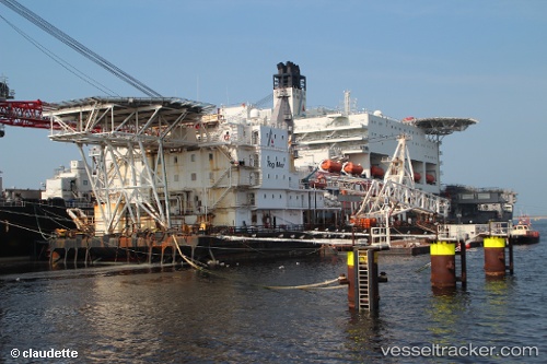
 Tog Mor
Current Status
Where is the vessel?
Tog Mor is currently in Near ROTTERDAM PERNIS, based on AIS data received less than 1h ago.
Latest AIS update:
Current position: 51.88755° N, 4.40258° E (Near ROTTERDAM PERNIS)
Average speed (last 7 days): Loading…
Average speed (last 30 days): Loading…
Vessel profile: Tog Mor is a Work Repair Vessel with dimensions 125m x 30m.
This page combines live AIS, route history, probable destination signals, nearby traffic, and port activity for practical vessel monitoring.
The current position of vessel Tog Mor is 51.88755 lat / 4.40258 lng. Updated: 2026-05-14 08:24:26 UTCNearest reference points:
- Near ROTTERDAM PERNIS
- Near Heijplaat
- Near ROTTERDAM WAALHAVEN
Currently sailing under the flag of Malta ![]()
Tog Mor built in 1976 year
Deadweight:
20627 tDetails:
Live Vessel Tog Mor Analytics (details, animations, etc.)
Recent AIS points (UTC):
2026-05-14 04:33:24 UTC · 51.88759, 4.40256 · SOG 0 kn · COG 333°2026-05-14 05:45:25 UTC · 51.88758, 4.40256 · SOG 0 kn · COG 333°
2026-05-14 07:57:26 UTC · 51.88756, 4.40257 · SOG 0 kn · COG 332°
2026-05-14 08:24:26 UTC · 51.88755, 4.40258 · SOG 0 kn · COG 332°