 vesseltracker.com
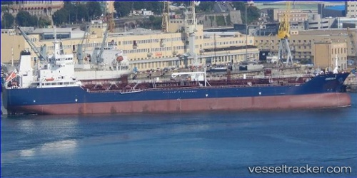
 Greta K
Current Status
Where is the vessel?
Greta K is currently in Near Zona Franca de Barcelona, based on AIS data received less than 1h ago.
Latest AIS update:
Current position: 41.33838° N, 2.16561° E (Near Zona Franca de Barcelona)
Average speed (last 7 days): Loading…
Average speed (last 30 days): Loading…
Vessel profile: Greta K is a Chemical Oil Products Tanker with dimensions 158m x 26m.
This page combines live AIS, route history, probable destination signals, nearby traffic, and port activity for practical vessel monitoring.
The current position of vessel Greta K is 41.33838 lat / 2.16561 lng. Updated: 2026-04-26 16:36:58 UTCNearest reference points:
- Near Zona Franca de Barcelona
- Near Barcelona
- Near BADALONA
Currently sailing under the flag of Malta ![]()
Details:
Live Vessel Greta K Analytics (details, animations, etc.)
Recent AIS points (UTC):
2026-04-26 13:03:55 UTC · 41.33839, 2.16560 · SOG 0 kn · COG 192°2026-04-26 13:57:54 UTC · 41.33837, 2.16560 · SOG 0 kn · COG 192°
2026-04-26 16:03:55 UTC · 41.33837, 2.16560 · SOG 0 kn · COG 192°
2026-04-26 16:36:58 UTC · 41.33838, 2.16561 · SOG 0 kn · COG 192°