 vesseltracker.com
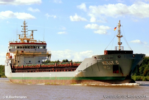
 KELLY C
Current Status
Where is the vessel?
KELLY C is currently in 24 nm NE of Sarinena, based on AIS data received about 1h ago.
Latest AIS update:
Current position: 42.14833° N, 9.79000° W (24 nm NE of Sarinena)
Average speed (last 7 days): Loading…
Average speed (last 30 days): Loading…
Vessel profile: KELLY C is a General Cargo Ship with dimensions 106m x 15m.
This page combines live AIS, route history, probable destination signals, nearby traffic, and port activity for practical vessel monitoring.
The current position of vessel KELLY C is 42.14833 lat / -9.79000 lng. Updated: 2026-05-13 19:39:12 UTCNearest reference points:
- 11 nm S of Sarinena
- 40 nm NW of Sarinena
- Near Corujo
Currently sailing under the flag of Portugal (MAR) ![]()
KELLY C built in 2010 year
Deadweight:
6700 tDetails:
Live Vessel KELLY C Analytics (details, animations, etc.)
Recent AIS points (UTC):
2026-05-13 16:11:41 UTC · 41.70667, -9.79667 · SOG 8 kn · COG -1°2026-05-13 18:08:58 UTC · 41.96167, -9.79333 · SOG 8 kn · COG -1°
2026-05-13 19:06:03 UTC · 42.07667, -9.79167 · SOG 7 kn · COG -1°
2026-05-13 19:39:12 UTC · 42.14833, -9.79000 · SOG 8 kn · COG -1°