 vesseltracker.com
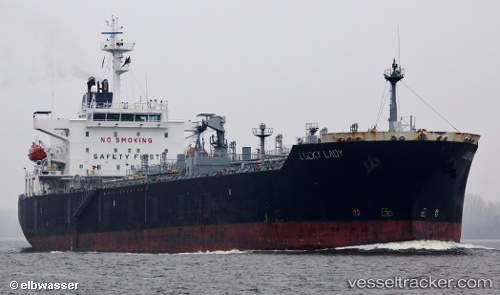
 Lucky Lady
Current Status
Where is the vessel?
Lucky Lady is currently in Near EL DEKHEILA, based on AIS data received less than 1h ago.
Latest AIS update:
Current position: 31.23090° N, 29.69654° E (Near EL DEKHEILA)
Average speed (last 7 days): Loading…
Average speed (last 30 days): Loading…
Vessel profile: Lucky Lady is a Chemical Oil Products Tanker with dimensions 176m x 31m.
This page combines live AIS, route history, probable destination signals, nearby traffic, and port activity for practical vessel monitoring.
The current position of vessel Lucky Lady is 31.23090 lat / 29.69654 lng. Updated: 2026-04-19 22:16:39 UTCNearest reference points:
- Near EL DEKHEILA
- Near Alexandria
- 13 nm W of EL DEKHEILA
Currently sailing under the flag of Malta ![]()
Lucky Lady built in 2005 year
Deadweight:
37432 tDetails:
Live Vessel Lucky Lady Analytics (details, animations, etc.)
Recent AIS points (UTC):
2026-04-19 17:35:44 UTC · 31.23112, 29.69660 · SOG 0 kn · COG 327°2026-04-19 19:05:49 UTC · 31.23107, 29.69661 · SOG 0.1 kn · COG 322°
2026-04-19 22:07:43 UTC · 31.23103, 29.69681 · SOG 0.1 kn · COG 311°
2026-04-19 22:16:39 UTC · 31.23090, 29.69654 · SOG 0.1 kn · COG 323°