 vesseltracker.com
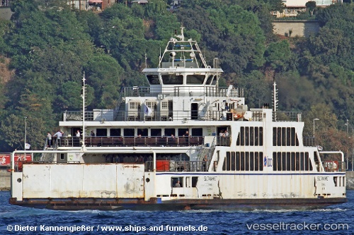
 Mf Sultanahmet
Current Status
Where is the vessel?
Mf Sultanahmet is currently in Near ESKIHISAR, based on AIS data received less than 1h ago.
Latest AIS update:
Current position: 40.76588° N, 29.42272° E (Near ESKIHISAR)
Average speed (last 7 days): Loading…
Average speed (last 30 days): Loading…
Vessel profile: Mf Sultanahmet is a Passenger Ro Ro Cargo Ship with dimensions 74m x 18m.
This page combines live AIS, route history, probable destination signals, nearby traffic, and port activity for practical vessel monitoring.
The current position of vessel Mf Sultanahmet is 40.76588 lat / 29.42272 lng. Updated: 2026-05-17 07:42:09 UTCNearest reference points:
- Near YALOVA
- Near Tuzla Free Zone
- Near Yilport
Currently sailing under the flag of Turkey ![]()
Mf Sultanahmet built in 2008 year
Deadweight:
250 tDetails:
Live Vessel Mf Sultanahmet Analytics (details, animations, etc.)
Recent AIS points (UTC):
2026-05-17 04:30:11 UTC · 40.76583, 29.42273 · SOG 0.1 kn · COG -1°2026-05-17 06:18:10 UTC · 40.76588, 29.42272 · SOG 0.1 kn · COG -1°
2026-05-17 07:21:09 UTC · 40.76587, 29.42275 · SOG 0 kn · COG -1°
2026-05-17 07:42:09 UTC · 40.76588, 29.42272 · SOG 0 kn · COG -1°