 vesseltracker.com
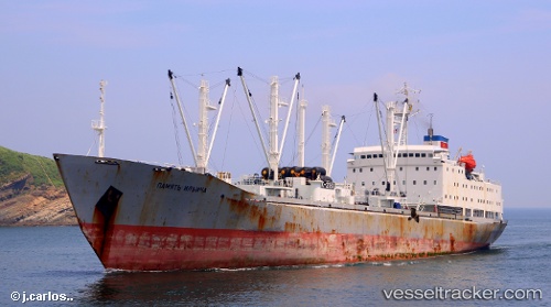
Pamyat Ilicha
Current StatusWhere is the vessel?
Pamyat Ilicha is currently in Near Majistan/Zhoushan, based on AIS data received about 1h ago.
Latest AIS update:
Current position: 29.98823° N, 122.13482° E (Near Majistan/Zhoushan)
Average speed (last 7 days): Loading…
Average speed (last 30 days): Loading…
Vessel profile: Pamyat Ilicha is a Refrigerated Cargo Ship with dimensions 22m x 152m.
This page combines live AIS, route history, probable destination signals, nearby traffic, and port activity for practical vessel monitoring.
The current position of vessel Pamyat Ilicha is 29.98823 lat / 122.13482 lng. Updated: 2026-05-15 12:08:46 UTCNearest reference points:
- Near Majistan/Zhoushan
- Near ZHOUSHAN
- Near Daxie Pt
Details:
Live Vessel Pamyat Ilicha Analytics (details, animations, etc.)
Recent AIS points (UTC):
2026-05-15 07:50:44 UTC · 29.98826, 122.13483 · SOG 0 kn · COG 71°2026-05-15 09:53:56 UTC · 29.98667, 122.13333 · SOG 0 kn · COG -1°
2026-05-15 10:23:44 UTC · 29.98827, 122.13486 · SOG 0 kn · COG -1°
2026-05-15 12:08:46 UTC · 29.98823, 122.13482 · SOG 0 kn · COG -1°