 vesseltracker.com
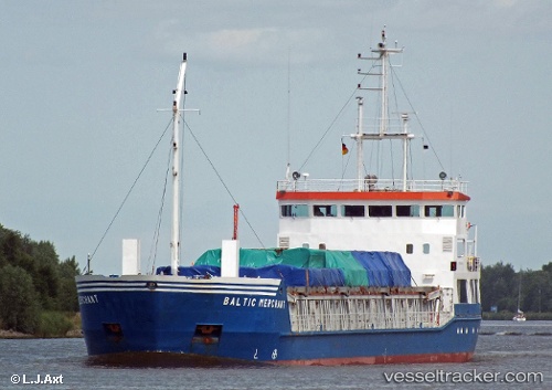
 BALTIC MERCHANT
Current Status
Where is the vessel?
BALTIC MERCHANT is currently in 35 nm E of Tomtbod, based on AIS data received less than 1h ago.
Latest AIS update:
Current position: 57.16021° N, 19.59972° E (35 nm E of Tomtbod)
Average speed (last 7 days): Loading…
Average speed (last 30 days): Loading…
Vessel profile: BALTIC MERCHANT is a General Cargo Ship with dimensions 82m x 12m.
This page combines live AIS, route history, probable destination signals, nearby traffic, and port activity for practical vessel monitoring.
The current position of vessel BALTIC MERCHANT is 57.16021 lat / 19.59972 lng. Updated: 2026-05-16 15:33:50 UTCNearest reference points:
- 39 nm W of Pilies juru uosto PVP/Klaipeda
- Near Cimdenieki
- 37 nm W of Vikati Sadam
Currently sailing under the flag of Latvia ![]()
BALTIC MERCHANT built in 1997 year
Deadweight:
3110 tDetails:
Live Vessel BALTIC MERCHANT Analytics (details, animations, etc.)
Recent AIS points (UTC):
2026-05-16 11:55:19 UTC · 57.41736, 20.57722 · SOG 9.8 kn · COG 243°2026-05-16 13:33:30 UTC · 57.30260, 20.13279 · SOG 9.9 kn · COG 240°
2026-05-16 14:07:09 UTC · 57.26177, 19.98033 · SOG 9.6 kn · COG 240°
2026-05-16 15:33:50 UTC · 57.16021, 19.59972 · SOG 9.2 kn · COG 246°