 vesseltracker.com
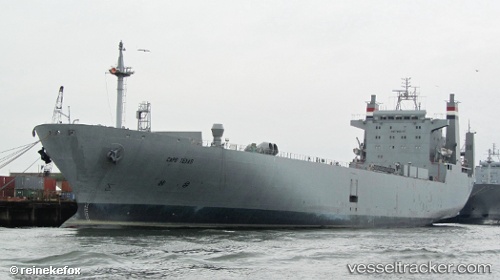
 CAPE TEXAS
Current Status
Where is the vessel?
CAPE TEXAS is currently in Near Tampa, based on AIS data received about 5d ago.
Latest AIS update:
Current position: 27.92666° N, 82.44362° W (Near Tampa)
Average speed (last 7 days): Loading…
Average speed (last 30 days): Loading…
Vessel profile: CAPE TEXAS is a Logistics Naval Vessel with dimensions m x m.
This page combines live AIS, route history, probable destination signals, nearby traffic, and port activity for practical vessel monitoring.
The current position of vessel CAPE TEXAS is 27.92666 lat / -82.44362 lng. Updated: 2026-04-22 01:07:42 UTCNearest reference points:
- Near Tampa
- Near St. Petersburg
- Near Saint Petersburg
Currently sailing under the flag of United States ![]()
Details:
Live Vessel CAPE TEXAS Analytics (details, animations, etc.)
Recent AIS points (UTC):
2026-04-22 01:07:42 UTC · 27.92666, -82.44362 · SOG 0 kn · COG 231°2026-04-22 01:07:42 UTC · 27.92666, -82.44362 · SOG 0 kn · COG 231°
2026-04-22 01:07:42 UTC · 27.92666, -82.44362 · SOG 0 kn · COG 231°
2026-04-22 01:07:42 UTC · 27.92666, -82.44362 · SOG 0 kn · COG 231°