 vesseltracker.com
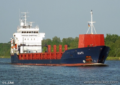
 KATI
KATI
Current Status
Where is the vessel?
KATI is currently in Near Le Harve, based on AIS data received less than 1h ago.
Latest AIS update:
Current position: 49.46833° N, 0.07333° W (Near Le Harve)
Average speed (last 7 days): Loading…
Average speed (last 30 days): Loading…
Vessel profile: KATI is a General Cargo Ship with dimensions 107m x 107m.
This page combines live AIS, route history, probable destination signals, nearby traffic, and port activity for practical vessel monitoring.
The current position of vessel KATI is 49.46833 lat / -0.07333 lng. Updated: 2026-04-18 07:45:10 UTCNearest reference points:
- Near Le Havre
- Near TROUVILLE-SUR-MER
- Near Caen
Currently sailing under the flag of Antigua and Barbuda ![]()
KATI built in 1998 year
Deadweight:
5145 tDetails:
Live Vessel KATI Analytics (details, animations, etc.)
Recent AIS points (UTC):
2026-04-18 01:22:01 UTC · 49.46918, -0.07717 · SOG 0.1 kn · COG 67°2026-04-18 03:31:02 UTC · 49.46893, -0.07744 · SOG 0.2 kn · COG 57°
2026-04-18 05:49:04 UTC · 49.46822, -0.07691 · SOG 0.2 kn · COG 31°
2026-04-18 07:45:10 UTC · 49.46833, -0.07333 · SOG 0 kn · COG -1°