 vesseltracker.com
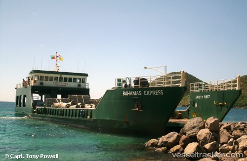
 BAHAMAS EXPRESS
Current Status
Where is the vessel?
BAHAMAS EXPRESS is currently in 16 nm SW of Stella Maris, based on AIS data received less than 1h ago.
Latest AIS update:
Current position: 23.40885° N, 75.50119° W (16 nm SW of Stella Maris)
Average speed (last 7 days): Loading…
Average speed (last 30 days): Loading…
Vessel profile: BAHAMAS EXPRESS is a Landing Craft with dimensions m x m.
This page combines live AIS, route history, probable destination signals, nearby traffic, and port activity for practical vessel monitoring.
The current position of vessel BAHAMAS EXPRESS is 23.40885 lat / -75.50119 lng. Updated: 2026-05-13 23:05:20 UTCNearest reference points:
- Near Great Exuma Island
- 30 nm SW of Cape Eleuthera
- 29 nm SW of Cape Eleuthera
Currently sailing under the flag of Antigua and Barbuda ![]()
Details:
Live Vessel BAHAMAS EXPRESS Analytics (details, animations, etc.)
Recent AIS points (UTC):
2026-05-13 19:43:49 UTC · 23.50766, -75.76723 · SOG 0 kn · COG 196°2026-05-13 19:46:48 UTC · 23.50766, -75.76723 · SOG 0 kn · COG 196°
2026-05-13 21:40:51 UTC · 23.49035, -75.70703 · SOG 8.5 kn · COG 90°
2026-05-13 23:05:20 UTC · 23.40885, -75.50119 · SOG 8 kn · COG 142°