 vesseltracker.com
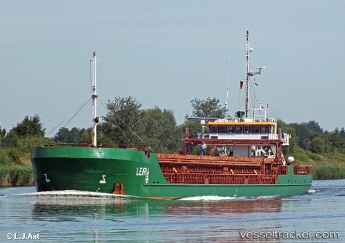
 Leiria
Current Status
Where is the vessel?
Leiria is currently in Near Auderville, based on AIS data received about 1h ago.
Latest AIS update:
Current position: 49.83108° N, 2.03585° W (Near Auderville)
Average speed (last 7 days): Loading…
Average speed (last 30 days): Loading…
Vessel profile: Leiria is a General Cargo Ship with dimensions 89m x 11m.
This page combines live AIS, route history, probable destination signals, nearby traffic, and port activity for practical vessel monitoring.
The current position of vessel Leiria is 49.83108 lat / -2.03585 lng. Updated: 2026-04-10 02:38:01 UTCNearest reference points:
- Near ALDERNEY
- Near Équeurdreville
- Near Cherbourg
Currently sailing under the flag of Antigua Barbuda ![]()
Leiria built in 2003 year
Deadweight:
2652 tDetails:
Live Vessel Leiria Analytics (details, animations, etc.)
Recent AIS points (UTC):
2026-04-09 19:23:22 UTC · 49.69840, -2.86635 · SOG 4.2 kn · COG 47°2026-04-09 21:27:02 UTC · 49.75181, -2.66607 · SOG 4.3 kn · COG 51°
2026-04-10 00:31:02 UTC · 49.82305, -2.29770 · SOG 5.3 kn · COG 73°
2026-04-10 02:38:01 UTC · 49.83108, -2.03585 · SOG 4.3 kn · COG 75°