 vesseltracker.com
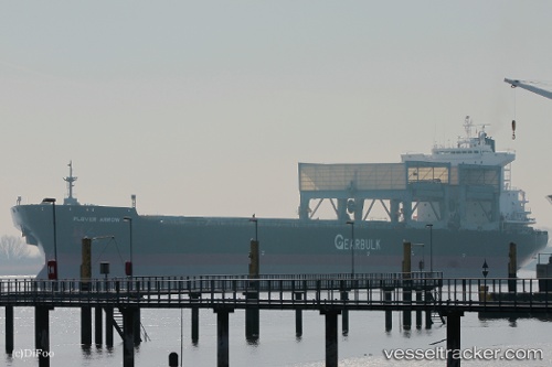
 Plover Arrow
Current Status
Where is the vessel?
Plover Arrow is currently in Near Harmac, based on AIS data received about 1h ago.
Latest AIS update:
Current position: 49.14470° N, 123.84600° W (Near Harmac)
Average speed (last 7 days): Loading…
Average speed (last 30 days): Loading…
Vessel profile: Plover Arrow is a Multi Purpose Carrier with dimensions 200m x 32m.
This page combines live AIS, route history, probable destination signals, nearby traffic, and port activity for practical vessel monitoring.
The current position of vessel Plover Arrow is 49.14470 lat / -123.84600 lng. Updated: 2026-05-01 16:04:16 UTCNearest reference points:
- Near Harmac
- Near Nanaimo
- Near Cassidy
Currently sailing under the flag of Bahamas ![]()
Plover Arrow built in 1997 year
Deadweight:
51421 tDetails:
Live Vessel Plover Arrow Analytics (details, animations, etc.)
Recent AIS points (UTC):
2026-05-01 13:21:01 UTC · 49.14387, -123.84777 · SOG 0.2 kn · COG 338°2026-05-01 14:21:01 UTC · 49.14480, -123.84640 · SOG 0 kn · COG 292°
2026-05-01 15:27:03 UTC · 49.14467, -123.84646 · SOG 0 kn · COG 294°
2026-05-01 16:04:16 UTC · 49.14470, -123.84600 · SOG 0 kn · COG 296°