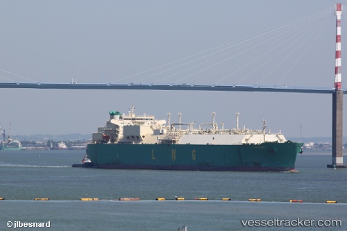
.
Vessel photo of Lng Borno (IMO 9322803) vesseltracker.com

Lng Borno

Vessel type: Lng Tanker | IMO: 9322803 | MMSI: MMSI: 310543000
Call sign: ZCDW4 | Dimensions: 44 m x 285 m
Current Status

Where is the vessel?

Lng Borno is currently in 67 nm NW of CASADO, based on AIS data received about 2h ago.

Latest AIS update:

Current position: 21.30645° N, 18.11886° W (67 nm NW of CASADO)

Average speed (last 7 days): Loading…

Average speed (last 30 days): Loading…

Vessel profile: Lng Borno is a Lng Tanker with dimensions 44m x 285m.

This page combines live AIS, route history, probable destination signals, nearby traffic, and port activity for practical vessel monitoring.

The current position of vessel Lng Borno is 21.30645 lat / -18.11886 lng. Updated: 2026-03-28 19:49:56 UTC
Nearest reference points:
  • 41 nm NW of Nouadhibou
  • Near Nouadhibou
  • 108 nm SW of Port Etienne
Details:

Live Vessel Lng Borno Analytics (details, animations, etc.)


Recent AIS points (UTC):
2026-03-28 14:06:40 UTC · 19.74377, -18.19439 · SOG 16.2 kn · COG 359°
2026-03-28 16:18:02 UTC · 20.35017, -18.23608 · SOG 16.5 kn · COG 3°
2026-03-28 18:21:56 UTC · 20.92078, -18.22169 · SOG 15.9 kn · COG 15°
2026-03-28 19:49:56 UTC · 21.30645, -18.11886 · SOG 16.3 kn · COG 15°

Track of the vessel in the last 28 days


UTC: --
Start: -- Track timeline (UTC) End: --
Encountered: --


Link to the map:


Find another ship

Lng_Borno (310543000) last ports (portcalls and passsages)

JURONG ISLAND | 2025-08-03 22:41:36
BUKOM ISLAND | 2025-08-02 19:06:41
PULAU SAMBU | 2025-08-02 18:22:13
BATU AMPAR | 2025-08-02 17:21:37
PENGERANG | 2025-08-02 04:27:51
TANAH MERAH | 2025-08-02 03:32:05
CHANGI | 2025-08-02 02:53:07
SEMBAWANG | 2025-08-01 11:52:27
PASIR GUDANG | 2025-08-01 10:46:33
SEMBAWANG | 2025-07-28 11:25:12
PASIR GUDANG | 2025-07-28 10:07:39
SEMBAWANG | 2025-07-24 11:04:39
PASIR GUDANG | 2025-07-24 09:09:48
SEMBAWANG | 2025-07-20 10:45:23
PASIR GUDANG | 2025-07-20 08:36:13
SEMBAWANG | 2025-07-16 09:45:18
CHANGI | 2025-07-16 08:26:08
TANAH MERAH | 2025-07-15 04:14:42
PENGERANG | 2025-07-15 01:46:53
BATU AMPAR | 2025-07-15 00:24:56
PULAU SAMBU | 2025-07-14 23:56:43
Cochin | 2025-07-06 06:33:21
Bonny | 2025-06-06 20:23:25
Port Louis | 2025-05-16 04:18:52
DAHEJ | 2025-05-02 19:07:39
Bonny | 2025-03-26 22:42:51
Durban | 2025-02-19 08:50:44
Cochin | 2025-02-01 02:06:21
Bonny | 2025-01-11 10:19:18
Walvisbaai | 2024-12-30 15:02:29
WALVIS BAY | 2024-12-30 11:41:11
PORT QASIM | 2024-12-07 04:50:07
Bonny | 2024-11-07 16:28:40
Bonny | 2024-10-04 13:19:17
Bonny | 2024-07-08 00:20:23
Bonny | 2024-05-15 17:17:01
Walvisbaai | 2024-04-22 07:25:37
Bonny | 2024-03-05 21:47:22
Durban | 2024-02-14 12:09:00
Bonny | 2024-01-09 12:47:17
Luanda | 2024-01-06 05:05:16
Bonny | 2023-10-23 22:13:01
Bonny | 2023-09-30 14:26:43
Bilbao | 2023-09-07 05:25:19
Urdiales | 2023-09-07 03:58:29
Bonny | 2023-08-20 05:21:08
Durban | 2023-08-03 09:46:07
Cochin | 2023-07-23 00:52:47
Bonny | 2023-06-28 18:28:35
Strait Of Gibraltar | 2023-06-01 23:38:29
Cartagena | 2023-05-30 21:51:40
Bonny | 2023-05-12 04:20:08
Port Louis | 2023-04-24 07:22:35
Durban | 2023-03-28 11:12:56
Bonny | 2023-03-17 08:44:58
Durban | 2023-02-23 11:25:03
Mina Saud | 2023-02-05 21:09:14
Bonny | 2023-01-09 17:08:47
Bonny | 2022-12-09 17:59:52
Bonny | 2022-07-22 22:16:19
Huelva | 2022-07-02 04:03:32
Bonny | 2022-06-20 04:46:48
Strait Of Gibraltar | 2022-05-24 04:19:59
Alicante | 2022-05-22 16:27:15
Bonny | 2022-05-08 04:10:59
Bonny | 2022-03-22 18:15:04
Port Des Galets | 2022-03-03 09:25:12
Sambu | 2022-02-21 03:35:39
Niigata | 2022-02-03 02:00:06
Port Des Galets | 2022-01-14 05:40:15
Bonny | 2021-12-30 23:48:08
Port Des Galets | 2021-12-15 05:40:43