 vesseltracker.com
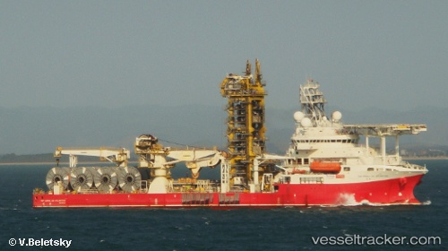
 CORAL DO ATLANTICO
Current Status
Where is the vessel?
CORAL DO ATLANTICO is currently in 29 nm W of Aguçadoura, based on AIS data received less than 1h ago.
Latest AIS update:
Current position: 41.35867° N, 9.40924° W (29 nm W of Aguçadoura)
Average speed (last 7 days): Loading…
Average speed (last 30 days): Loading…
Vessel profile: CORAL DO ATLANTICO is a Not available with dimensions m x m.
This page combines live AIS, route history, probable destination signals, nearby traffic, and port activity for practical vessel monitoring.
The current position of vessel CORAL DO ATLANTICO is 41.35867 lat / -9.40924 lng. Updated: 2026-05-15 11:46:38 UTCNearest reference points:
- Near POVOA DE VARZIM
- 11 nm S of Sarinena
- Near Matosinhos
Currently sailing under the flag of Bahamas ![]()
Details:
Live Vessel CORAL DO ATLANTICO Analytics (details, animations, etc.)
Recent AIS points (UTC):
2026-05-15 08:15:15 UTC · 41.36162, -9.40954 · SOG 0.9 kn · COG 310°2026-05-15 09:25:57 UTC · 41.35858, -9.40944 · SOG 0.1 kn · COG 336°
2026-05-15 10:07:38 UTC · 41.35847, -9.40940 · SOG 0.1 kn · COG 336°
2026-05-15 11:46:38 UTC · 41.35867, -9.40924 · SOG 0.2 kn · COG 10°