 vesseltracker.com
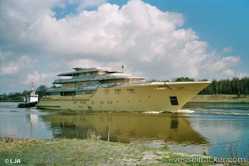
 DEJA TOO
Current Status
Where is the vessel?
DEJA TOO is currently in Open sea, approx. 441 nm off the nearest listed port, based on AIS data received about 2h ago.
Latest AIS update:
Current position: 28.79952° N, 49.65581° W (Open sea, approx. 441 nm off the nearest listed port)
Average speed (last 7 days): Loading…
Average speed (last 30 days): Loading…
Vessel profile: DEJA TOO is a Houseboat with dimensions 52m x 9m.
This page combines live AIS, route history, probable destination signals, nearby traffic, and port activity for practical vessel monitoring.
The current position of vessel DEJA TOO is 28.79952 lat / -49.65581 lng. Updated: 2026-04-25 18:45:50 UTCNearest reference points:
- Open sea, approx. 441 nm off the nearest listed port
- Open sea, approx. 438 nm off the nearest listed port
- Open sea, approx. 436 nm off the nearest listed port
Currently sailing under the flag of Cayman Islands ![]()
DEJA TOO built in 2003 year
Deadweight:
134 tDetails:
Live Vessel DEJA TOO Analytics (details, animations, etc.)
Recent AIS points (UTC):
2026-04-25 16:57:14 UTC · 28.72428, -50.06591 · SOG 12.2 kn · COG 77°2026-04-25 17:44:50 UTC · 28.75966, -49.88641 · SOG 12.3 kn · COG 81°
2026-04-25 18:39:50 UTC · 28.79534, -49.67871 · SOG 12 kn · COG 82°
2026-04-25 18:45:50 UTC · 28.79952, -49.65581 · SOG 12.2 kn · COG 81°