 vesseltracker.com
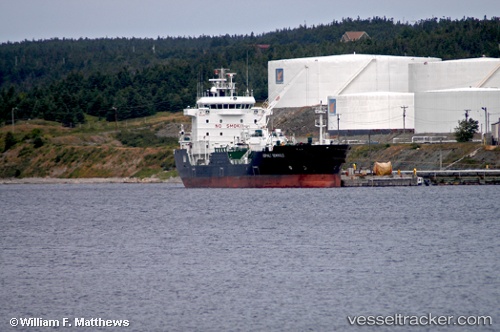
 ASPHALT TERANGA
Current Status
Where is the vessel?
ASPHALT TERANGA is currently in 72 nm SE of Nedroma, based on AIS data received less than 1h ago.
Latest AIS update:
Current position: 33.96422° N, 13.95173° W (72 nm SE of Nedroma)
Average speed (last 7 days): Loading…
Average speed (last 30 days): Loading…
Vessel profile: ASPHALT TERANGA is a Asphalt/Bitumen Tanker with dimensions 108m x 20m.
This page combines live AIS, route history, probable destination signals, nearby traffic, and port activity for practical vessel monitoring.
The current position of vessel ASPHALT TERANGA is 33.96422 lat / -13.95173 lng. Updated: 2026-05-14 17:53:18 UTCNearest reference points:
- 104 nm W of Jarjis
- 109 nm E of Porto Santo Island
- 101 nm SW of Jarjis
Currently sailing under the flag of Panama ![]()
ASPHALT TERANGA built in 2005 year
Deadweight:
9230 tDetails:
Live Vessel ASPHALT TERANGA Analytics (details, animations, etc.)
Recent AIS points (UTC):
2026-05-14 12:41:48 UTC · 33.14185, -14.08070 · SOG 9.6 kn · COG 4°2026-05-14 15:32:41 UTC · 33.60194, -14.01090 · SOG 9.3 kn · COG 7°
2026-05-14 16:10:18 UTC · 33.70186, -13.99907 · SOG 9.7 kn · COG 8°
2026-05-14 17:53:18 UTC · 33.96422, -13.95173 · SOG 8.9 kn · COG 10°