 vesseltracker.com
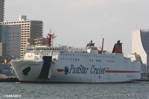
 YAIMAMARU
Current Status
Where is the vessel?
YAIMAMARU is currently in Near PA-TOU-TZU, based on AIS data received about 1h ago.
Latest AIS update:
Current position: 25.15446° N, 121.76196° E (Near PA-TOU-TZU)
Average speed (last 7 days): Loading…
Average speed (last 30 days): Loading…
Vessel profile: YAIMAMARU is a Ro-Ro/Passenger Ship with dimensions m x m.
This page combines live AIS, route history, probable destination signals, nearby traffic, and port activity for practical vessel monitoring.
The current position of vessel YAIMAMARU is 25.15446 lat / 121.76196 lng. Updated: 2026-04-26 10:02:09 UTCNearest reference points:
- Near PA-TOU-TZU
- Near Chi-Lung
- Near SHEN AO
Currently sailing under the flag of Panama ![]()
Details:
Live Vessel YAIMAMARU Analytics (details, animations, etc.)
Recent AIS points (UTC):
2026-04-26 07:23:52 UTC · 25.15442, 121.76197 · SOG 0 kn · COG 0°2026-04-26 07:56:09 UTC · 25.15448, 121.76194 · SOG 0 kn · COG 0°
2026-04-26 09:44:09 UTC · 25.15444, 121.76194 · SOG 0 kn · COG 0°
2026-04-26 10:02:09 UTC · 25.15446, 121.76196 · SOG 0 kn · COG 0°