 vesseltracker.com
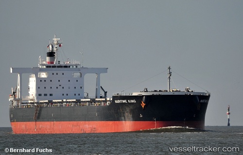
 Maritime King
Current Status
Where is the vessel?
Maritime King is currently in 16 nm W of Tanjong Bin, based on AIS data received about 1h ago.
Latest AIS update:
Current position: 1.33813° N, 103.27942° E (16 nm W of Tanjong Bin)
Average speed (last 7 days): Loading…
Average speed (last 30 days): Loading…
Vessel profile: Maritime King is a Bulk Carrier with dimensions 235m x 38m.
This page combines live AIS, route history, probable destination signals, nearby traffic, and port activity for practical vessel monitoring.
The current position of vessel Maritime King is 1.33813 lat / 103.27942 lng. Updated: 2026-05-16 13:52:05 UTCNearest reference points:
- 15 nm W of Tanjong Bin
- 19 nm W of Tanjong Bin
- Near Tanjungbalai
Currently sailing under the flag of Panama ![]()
Maritime King built in 2011 year
Deadweight:
95675 tDetails:
Live Vessel Maritime King Analytics (details, animations, etc.)
Recent AIS points (UTC):
2026-05-16 10:29:26 UTC · 1.17693, 103.80947 · SOG 11.8 kn · COG 247°2026-05-16 12:26:15 UTC · 1.22828, 103.47323 · SOG 10.1 kn · COG 283°
2026-05-16 13:39:35 UTC · 1.31909, 103.30410 · SOG 9 kn · COG 308°
2026-05-16 13:52:05 UTC · 1.33813, 103.27942 · SOG 8.9 kn · COG 308°