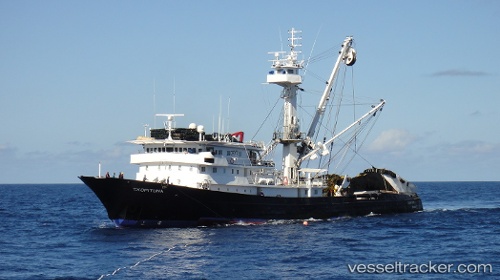
.
Vessel photo of Txopituna (IMO 8719310) vesseltracker.com

Txopituna

Vessel type: Fishing Vessel | IMO: 8719310 | MMSI: MMSI: 353770000
Call sign: 3EYS | Dimensions: 15 m x 70 m
Current Status

Where is the vessel?

Txopituna is currently in 224 nm SW of Puerto Villamil, Isla Isabela, based on AIS data received about 19d ago.

Latest AIS update:

Current position: 2.35808° S, 94.46335° W (224 nm SW of Puerto Villamil, Isla Isabela)

Average speed (last 7 days): Loading…

Average speed (last 30 days): Loading…

Vessel profile: Txopituna is a Fishing Vessel with dimensions 15m x 70m.

This page combines live AIS, route history, probable destination signals, nearby traffic, and port activity for practical vessel monitoring.

The current position of vessel Txopituna is -2.35808 lat / -94.46335 lng. Updated: 2026-04-25 01:18:31 UTC
Nearest reference points:
  • Open sea, approx. 412 nm off the nearest listed port
Details:

Live Vessel Txopituna Analytics (details, animations, etc.)


Recent AIS points (UTC):
2026-04-25 01:18:31 UTC · -2.35808, -94.46335 · SOG 9.7 kn · COG 277°

Track of the vessel in the last 60 days


UTC: --
Start: -- Track timeline (UTC) End: --
Encountered: --


Link to the map:


Find another ship

Txopituna (353770000) last ports (portcalls and passsages)

Rodman | 2025-05-10 02:17:26
TABOGA | 2025-05-10 00:21:36
Rodman | 2025-03-04 19:40:05
TABOGA | 2025-03-04 07:50:55
Rodman | 2024-12-18 16:27:43
TABOGA | 2024-12-18 06:28:11
Rodman | 2024-10-20 10:28:31
Callao | 2024-10-10 13:54:28
Callao | 2024-10-06 13:30:08
Callao | 2024-10-02 13:15:14
Callao | 2024-09-28 11:49:51
Callao | 2024-09-24 11:45:49
Callao | 2024-09-20 11:34:15
Callao | 2022-10-24 20:02:51
Callao | 2022-10-20 16:42:37
Callao | 2022-10-16 16:24:03
Callao | 2022-10-12 14:04:36
Callao | 2022-10-08 13:46:21
Callao | 2022-10-04 11:06:10
Callao | 2022-09-30 10:16:52
Callao | 2022-09-26 10:11:07
Callao | 2022-09-22 08:01:16
Callao | 2022-09-18 07:57:31
Callao | 2022-09-14 04:12:41