 vesseltracker.com
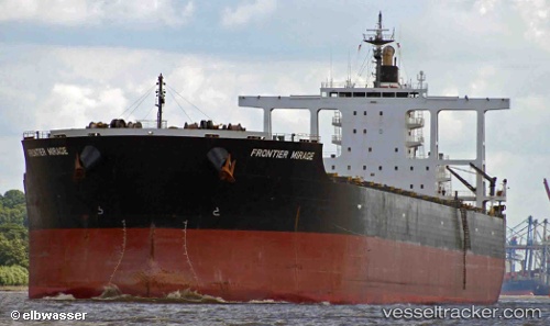
 Frontier Mirage
Current Status
Where is the vessel?
Frontier Mirage is currently in 46 nm W of Calatagan, based on AIS data received about 1h ago.
Latest AIS update:
Current position: 13.89679° N, 119.85204° E (46 nm W of Calatagan)
Average speed (last 7 days): Loading…
Average speed (last 30 days): Loading…
Vessel profile: Frontier Mirage is a Bulk Carrier with dimensions 289m x 45m.
This page combines live AIS, route history, probable destination signals, nearby traffic, and port activity for practical vessel monitoring.
The current position of vessel Frontier Mirage is 13.89679 lat / 119.85204 lng. Updated: 2026-05-15 11:31:57 UTCNearest reference points:
- 19 nm SW of MARIVELES
- Near Nasugbu, Luzon
- Near Noveleta
Currently sailing under the flag of Panama ![]()
Frontier Mirage built in 2011 year
Deadweight:
181572 tDetails:
Live Vessel Frontier Mirage Analytics (details, animations, etc.)
Recent AIS points (UTC):
2026-05-15 07:52:06 UTC · 13.41845, 120.18221 · SOG 9.7 kn · COG 322°2026-05-15 10:22:37 UTC · 13.73671, 119.94181 · SOG 9.5 kn · COG 328°
2026-05-15 10:59:20 UTC · 13.81893, 119.88748 · SOG 9.4 kn · COG 335°
2026-05-15 11:31:57 UTC · 13.89679, 119.85204 · SOG 9.3 kn · COG 350°