 vesseltracker.com
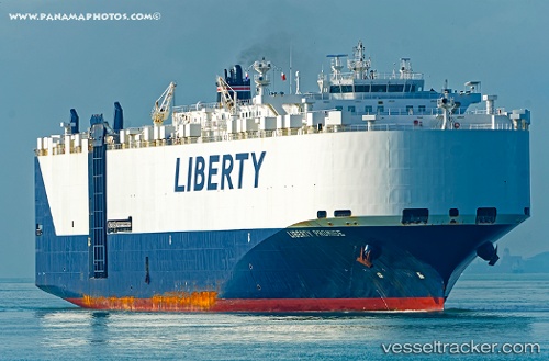
 Liberty Promise
Current Status
Where is the vessel?
Liberty Promise is currently in Near Hoevenen, based on AIS data received about 1h ago.
Latest AIS update:
Current position: 51.27195° N, 4.36098° E (Near Hoevenen)
Average speed (last 7 days): Loading…
Average speed (last 30 days): Loading…
Vessel profile: Liberty Promise is a Vehicles Carrier with dimensions 200m x 32m.
This page combines live AIS, route history, probable destination signals, nearby traffic, and port activity for practical vessel monitoring.
The current position of vessel Liberty Promise is 51.27195 lat / 4.36098 lng. Updated: 2026-04-30 04:59:01 UTCNearest reference points:
- Near Antwerp
- Near Kallo
- Near Kruibeke
Currently sailing under the flag of USA ![]()
Liberty Promise built in 2010 year
Deadweight:
21359 tDetails:
Live Vessel Liberty Promise Analytics (details, animations, etc.)
Recent AIS points (UTC):
2026-04-30 01:52:48 UTC · 51.27193, 4.36103 · SOG 0 kn · COG 308°2026-04-30 01:55:51 UTC · 51.27193, 4.36102 · SOG 0 kn · COG 308°
2026-04-30 04:22:56 UTC · 51.27192, 4.36104 · SOG 0 kn · COG 308°
2026-04-30 04:59:01 UTC · 51.27195, 4.36098 · SOG 0 kn · COG 308°