 vesseltracker.com
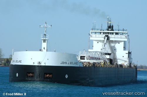
 John J Boland
Current Status
Where is the vessel?
John J Boland is currently in Near CALUMET HARBOR, based on AIS data received less than 1h ago.
Latest AIS update:
Current position: 41.69619° N, 87.55280° W (Near CALUMET HARBOR)
Average speed (last 7 days): Loading…
Average speed (last 30 days): Loading…
Vessel profile: John J Boland is a Self Discharging Bulk Carrier with dimensions 203m x 12m.
This page combines live AIS, route history, probable destination signals, nearby traffic, and port activity for practical vessel monitoring.
The current position of vessel John J Boland is 41.69619 lat / -87.55280 lng. Updated: 2026-05-02 13:44:13 UTCNearest reference points:
- Near Burnham
- Near Burns Harbor
- Near WAUKEGAN
Currently sailing under the flag of USA ![]()
John J Boland built in 1973 year
Deadweight:
33438 tDetails:
Live Vessel John J Boland Analytics (details, animations, etc.)
Recent AIS points (UTC):
2026-05-02 10:06:13 UTC · 41.69607, -87.55276 · SOG 0 kn · COG 157°2026-05-02 11:28:43 UTC · 41.69606, -87.55274 · SOG 0 kn · COG 157°
2026-05-02 13:31:34 UTC · 41.69615, -87.55279 · SOG 0 kn · COG 157°
2026-05-02 13:44:13 UTC · 41.69619, -87.55280 · SOG 0.2 kn · COG 157°