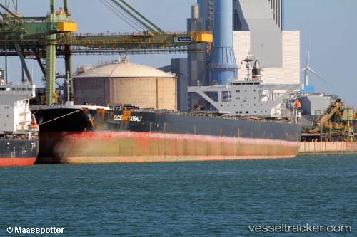
.
Vessel photo of Ocean Cobalt (IMO 9439137) vesseltracker.com

Ocean Cobalt

Vessel type: Bulk Carrier | IMO: 9439137 | MMSI: MMSI: 370272000
Call sign: 3ESD9 | Dimensions: 45 m x 289 m
Current Status

Where is the vessel?

Ocean Cobalt is currently in 84 nm SE of Fort Dauphin, based on AIS data received less than 1h ago.

Latest AIS update:

Current position: 25.92510° S, 48.20558° E (84 nm SE of Fort Dauphin)

Average speed (last 7 days): Loading…

Average speed (last 30 days): Loading…

Vessel profile: Ocean Cobalt is a Bulk Carrier with dimensions 45m x 289m.

This page combines live AIS, route history, probable destination signals, nearby traffic, and port activity for practical vessel monitoring.

The current position of vessel Ocean Cobalt is -25.92510 lat / 48.20558 lng. Updated: 2026-04-27 10:00:47 UTC
Nearest reference points:
  • 174 nm S of Ambovombe
  • 106 nm S of Tsiombe
Details:

Live Vessel Ocean Cobalt Analytics (details, animations, etc.)


Recent AIS points (UTC):
2026-04-27 05:44:16 UTC · -25.57358, 48.99500 · SOG 11.2 kn · COG 243°
2026-04-27 07:44:05 UTC · -25.74367, 48.61680 · SOG 11.2 kn · COG 243°
2026-04-27 08:24:49 UTC · -25.79698, 48.49083 · SOG 10.7 kn · COG 241°
2026-04-27 10:00:47 UTC · -25.92510, 48.20558 · SOG 10.8 kn · COG 239°

Track of the vessel in the last 60 days


UTC: --
Start: -- Track timeline (UTC) End: --
Encountered: --


Link to the map:


Find another ship

Ocean_Cobalt (370272000) last ports (portcalls and passsages)

Qingdao | 2025-08-22 05:06:32
Qingdao | 2025-08-18 04:28:08
DONGJIAKOU | 2025-07-09 08:19:27
BAKAUHENI | 2025-06-24 19:03:10
BUKOM ISLAND | 2025-04-09 10:35:30
PULAU SAMBU | 2025-04-09 10:06:51
TANAH MERAH | 2025-04-08 18:21:25
PENGERANG | 2025-04-08 17:03:37
Taicang | 2025-03-30 00:17:07
Wusong | 2025-03-29 03:56:40
Jingjiang | 2025-03-28 22:43:45
ZHOUSHAN | 2025-03-28 01:18:52
Selat Lombok | 2025-03-14 21:27:46
PORT WALCOTT | 2025-03-10 13:38:22
Samson Point | 2025-03-10 12:35:28
DANDONG | 2025-01-30 01:20:07
Selat Lombok | 2025-01-15 22:46:50
Samson Point | 2025-01-11 22:25:16
PORT WALCOTT | 2025-01-10 06:41:22
Samson Point | 2025-01-07 22:24:03
Samson Point | 2025-01-03 22:18:33
Samson Point | 2024-12-30 22:17:31
Samson Point | 2024-12-26 22:00:29
Taku Bar | 2024-12-13 06:44:53
Ta-Ku | 2024-12-09 13:23:02
Dagu Bar | 2024-12-09 11:05:49
Qingdao | 2024-10-22 21:28:13
Qingdao | 2024-10-17 20:19:10
Qingdao | 2024-09-08 01:56:53
Qingdao | 2024-09-02 07:10:25
Qingdao | 2024-07-10 23:33:11
Dampier | 2024-06-18 11:42:44
Xiamen | 2024-04-17 11:38:55
Rizhao | 2024-04-05 07:28:06
Dampier | 2024-03-20 07:32:33
Dampier | 2024-02-16 01:12:56
Selat Lombok | 2024-02-07 10:37:29
Singapore | 2023-09-27 09:57:08
Qingdao | 2023-09-14 05:50:30
Qingdao | 2023-09-10 04:35:02
Selat Lombok | 2023-08-22 18:45:13
Dampier | 2023-08-18 04:42:11
Taku Bar | 2023-07-25 14:31:55
Sambu | 2023-07-12 08:26:55
Saldanha Bay | 2023-06-17 15:07:12
Saldanha Bay | 2023-06-05 10:57:55
Singapore | 2023-05-09 00:21:44
Sambu | 2023-05-08 23:31:15
Victoria | 2023-03-16 02:26:46
Victoria | 2023-02-28 23:30:39
Honshu | 2023-02-11 05:58:01
Taicang | 2023-01-23 08:55:15
Wusong | 2023-01-23 05:52:00
Qingdao | 2023-01-19 17:53:08
Dampier | 2022-12-31 11:31:47
Selat Lombok | 2022-12-26 08:26:23
Singapore | 2022-11-26 05:57:49
Balboa | 2022-09-04 07:31:56
Panama | 2022-09-01 16:19:24
Honshu | 2022-07-27 16:04:12
Kashima Ko | 2022-07-25 04:40:56
Sao Luiz | 2022-05-17 19:18:02
Strait Of Gibraltar | 2022-04-08 06:05:25
Algeciras | 2022-04-07 15:16:15
Canakkale | 2022-03-28 03:45:04
Uskudar | 2022-03-27 15:55:20
Zonguldak | 2022-03-20 00:50:17
Canakkale | 2022-03-17 15:15:17
Algeciras | 2022-03-09 15:40:09
Strait Of Gibraltar | 2022-03-08 18:30:08
Algeciras | 2022-02-04 04:40:01
Iskenderun | 2022-01-19 07:41:03
Algeciras | 2022-01-11 10:15:46
Strait Of Gibraltar | 2022-01-11 04:17:43
Santa Marta | 2021-12-24 21:31:51
Cristobal | 2021-12-23 20:40:46
Balboa | 2021-12-23 11:00:07
Panama | 2021-12-23 10:15:07
Panama | 2021-12-18 15:35:04