 vesseltracker.com
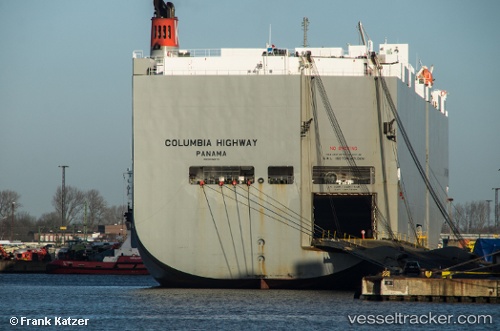
 Columbia Highway
Current Status
Where is the vessel?
Columbia Highway is currently in Near Cocoli, based on AIS data received about 1h ago.
Latest AIS update:
Current position: 9.01261° N, 79.60733° W (Near Cocoli)
Average speed (last 7 days): Loading…
Average speed (last 30 days): Loading…
Vessel profile: Columbia Highway is a Vehicles Carrier with dimensions 199m x 32m.
This page combines live AIS, route history, probable destination signals, nearby traffic, and port activity for practical vessel monitoring.
The current position of vessel Columbia Highway is 9.01261 lat / -79.60733 lng. Updated: 2026-04-12 18:12:15 UTCNearest reference points:
- Near Cocoli
- Near Panama Canal
- Near El Chorrillo
Currently sailing under the flag of Panama ![]()
Columbia Highway built in 2008 year
Deadweight:
18930 tDetails:
Live Vessel Columbia Highway Analytics (details, animations, etc.)
Recent AIS points (UTC):
2026-04-12 12:10:12 UTC · 9.27274, -79.92317 · SOG 1.3 kn · COG 188°2026-04-12 13:39:18 UTC · 9.21858, -79.93156 · SOG 0.2 kn · COG 21°
2026-04-12 16:24:14 UTC · 9.11060, -79.69862 · SOG 10.1 kn · COG 113°
2026-04-12 18:12:15 UTC · 9.01261, -79.60733 · SOG 3.7 kn · COG 132°