 vesseltracker.com
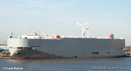
 Durban Highway
Current Status
Where is the vessel?
Durban Highway is currently in Near Long Beach, based on AIS data received less than 1h ago.
Latest AIS update:
Current position: 33.77352° N, 118.21928° W (Near Long Beach)
Average speed (last 7 days): Loading…
Average speed (last 30 days): Loading…
Vessel profile: Durban Highway is a Vehicles Carrier with dimensions 199m x 32m.
This page combines live AIS, route history, probable destination signals, nearby traffic, and port activity for practical vessel monitoring.
The current position of vessel Durban Highway is 33.77352 lat / -118.21928 lng. Updated: 2026-04-25 13:25:47 UTCNearest reference points:
- Near Long Beach
- Near Los Angeles
- Near Seal Beach
Currently sailing under the flag of Panama ![]()
Durban Highway built in 2011 year
Deadweight:
18906 tDetails:
Live Vessel Durban Highway Analytics (details, animations, etc.)
Recent AIS points (UTC):
2026-04-25 09:47:27 UTC · 33.53856, -118.13795 · SOG 8.5 kn · COG 342°2026-04-25 10:40:16 UTC · 33.65154, -118.17290 · SOG 6.7 kn · COG 350°
2026-04-25 12:14:56 UTC · 33.77060, -118.22263 · SOG 1.7 kn · COG 226°
2026-04-25 13:25:47 UTC · 33.77352, -118.21928 · SOG 0 kn · COG 238°