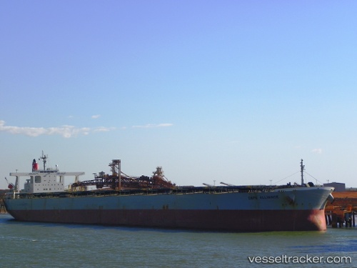
.
Vessel photo of Cape Alliance (IMO 9374038) vesseltracker.com

Cape Alliance

Vessel type: Ore Carrier | IMO: 9374038 | MMSI: MMSI: 372526000
Call sign: 3EJI2 | Dimensions: 50 m x 300 m
Current Status

Where is the vessel?

Cape Alliance is currently in Open sea, approx. 406 nm off the nearest listed port, based on AIS data received about 1h ago.

Latest AIS update:

Current position: 29.76250° S, 73.65695° E (Open sea, approx. 406 nm off the nearest listed port)

Average speed (last 7 days): Loading…

Average speed (last 30 days): Loading…

Vessel profile: Cape Alliance is a Ore Carrier with dimensions 50m x 300m.

This page combines live AIS, route history, probable destination signals, nearby traffic, and port activity for practical vessel monitoring.

The current position of vessel Cape Alliance is -29.76250 lat / 73.65695 lng. Updated: 2026-04-24 22:37:11 UTC
Nearest reference points:
  • Open sea, approx. 406 nm off the nearest listed port
  • Open sea, approx. 431 nm off the nearest listed port
  • Open sea, approx. 403 nm off the nearest listed port
Details:

Live Vessel Cape Alliance Analytics (details, animations, etc.)


Recent AIS points (UTC):
2026-04-24 20:03:28 UTC · -29.91040, 73.15106 · SOG 10.6 kn · COG 72°
2026-04-24 20:14:49 UTC · -29.90042, 73.18757 · SOG 10.5 kn · COG 72°
2026-04-24 21:37:37 UTC · -29.82054, 73.45571 · SOG 11.1 kn · COG 71°
2026-04-24 22:37:11 UTC · -29.76250, 73.65695 · SOG 11.1 kn · COG 73°

Track of the vessel in the last 60 days


UTC: --
Start: -- Track timeline (UTC) End: --
Encountered: --


Link to the map:


Find another ship

Cape_Alliance (372526000) last ports (portcalls and passsages)

JURONG ISLAND | 2025-07-06 13:23:34
PULAU SAMBU | 2025-07-06 12:02:01
BATU AMPAR | 2025-07-06 11:19:04
TANAH MERAH | 2025-07-05 18:55:07
PENGERANG | 2025-07-05 16:59:24
BAKAUHENI | 2025-06-04 00:07:23
PULAU SAMBU | 2025-03-08 18:49:53
TANAH MERAH | 2025-03-08 17:16:29
PENGERANG | 2025-03-08 16:20:34
LUOYUAN | 2025-02-26 12:17:37
LUOYUAN | 2025-02-22 11:18:53
LUOYUAN | 2025-02-18 09:39:43
LUOYUAN | 2025-02-14 09:26:15
Fangcheng | 2025-02-08 08:04:55
Fangcheng | 2025-02-04 07:50:46
Yen-Tai | 2024-10-12 18:04:26
Yen-Tai | 2024-10-08 16:30:20
Singapore | 2024-07-03 21:41:21
Ta-Ku | 2024-06-19 04:24:01
Taku Bar | 2024-06-19 01:42:58
Singapore | 2024-06-05 14:48:36
Sambu | 2024-06-05 12:10:57
Yosu | 2024-03-09 22:53:04
Yosu | 2024-03-05 21:31:51
Yosu | 2024-02-29 09:58:24
Samson Point | 2024-01-11 01:58:51
Selat Lombok | 2024-01-08 13:29:49
Kaohsiung | 2023-12-30 05:57:14
Tai-tung Kang | 2023-12-28 18:54:00
Tai-tung Kang | 2023-12-24 18:10:51
San Nicolas | 2023-08-20 14:28:28
San Nicolas | 2023-08-16 13:44:47
San Nicolas | 2023-08-12 13:33:19
Newcastle | 2023-06-17 23:48:32
Kaohsiung | 2023-05-28 11:36:13
Kao-Hsiung Kang | 2023-05-26 07:43:56
Kaohsiung | 2023-05-24 10:49:45
Kaohsiung | 2023-05-20 10:32:22
Kaohsiung | 2023-05-16 10:01:59
Selat Lombok | 2023-05-08 20:05:33
Dampier | 2023-05-04 23:23:16
Dampier | 2023-03-30 04:18:42
Yokosuka | 2023-03-13 20:46:13
Dampier | 2023-02-18 14:31:51
Selat Lombok | 2023-02-13 14:43:02
Pohang | 2023-01-06 11:45:10
Pohang | 2023-01-02 11:08:08
Selat Lombok | 2022-12-21 14:42:33
Samson Point | 2022-12-17 02:34:05
Pohang | 2022-12-01 11:48:44
Pohang | 2022-11-27 11:47:14
Port Headland | 2022-11-13 20:41:47
Port Headland | 2022-11-09 18:00:16
Port Headland | 2022-11-05 17:49:58
Port Headland | 2022-10-02 16:34:45
Yosu | 2022-09-18 04:34:01
Port Headland | 2022-08-25 07:43:55
Pohang | 2022-08-07 22:23:13
Yosu | 2022-08-02 22:15:14
Singapore | 2022-07-24 01:35:55
Singapore | 2022-05-08 22:59:51
Samson Point | 2022-04-01 05:27:02
Yosu | 2022-01-13 23:44:02
Port Headland | 2021-12-22 20:45:33
Port Hedland | 2021-12-22 20:40:05
Yosu | 2021-12-08 14:52:35