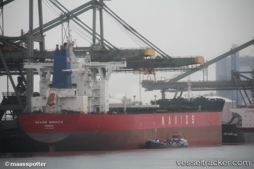
.
Vessel photo of Navios Bonavis (IMO 9446996) vesseltracker.com

Navios Bonavis

Vessel type: Bulk Carrier | IMO: 9446996 | MMSI: MMSI: 372755000
Call sign: 3FIS4 | Dimensions: 45 m x 292 m
Current Status

Where is the vessel?

Navios Bonavis is currently in Open sea (no nearby ports in database), based on AIS data received about 1h ago.

Latest AIS update:

Current position: 3.21305° S, 82.23067° E (Open sea (no nearby ports in database))

Average speed (last 7 days): Loading…

Average speed (last 30 days): Loading…

Vessel profile: Navios Bonavis is a Bulk Carrier with dimensions 45m x 292m.

This page combines live AIS, route history, probable destination signals, nearby traffic, and port activity for practical vessel monitoring.

The current position of vessel Navios Bonavis is -3.21305 lat / 82.23067 lng. Updated: 2026-03-29 14:13:12 UTC
Nearest reference points:
  • Open sea (no nearby ports in database)
Details:

Live Vessel Navios Bonavis Analytics (details, animations, etc.)


Recent AIS points (UTC):
2026-03-29 08:00:52 UTC · -3.92347, 81.27197 · SOG 12.2 kn · COG 53°
2026-03-29 09:19:51 UTC · -3.76330, 81.48008 · SOG 11.8 kn · COG 53°
2026-03-29 12:12:09 UTC · -3.43465, 81.92938 · SOG 11.3 kn · COG 56°
2026-03-29 14:13:12 UTC · -3.21305, 82.23067 · SOG 11.1 kn · COG 56°

Track of the vessel in the last 28 days


UTC: --
Start: -- Track timeline (UTC) End: --
Encountered: --


Link to the map:


Find another ship

Navios_Bonavis (372755000) last ports (portcalls and passsages)

BUKOM ISLAND | 2025-08-20 17:24:26
TANAH MERAH | 2025-08-20 04:09:47
PENGERANG | 2025-08-20 01:21:14
ZHUHAI | 2025-08-15 03:08:53
ZHUHAI | 2025-08-11 01:59:16
TANAH MERAH | 2025-07-31 16:10:56
PULAU SAMBU | 2025-07-31 14:35:30
Panama | 2025-05-17 13:57:57
TABOGA | 2025-05-17 11:33:41
Lazaro Cardenas | 2025-05-08 10:25:09
Lazaro Cardenas | 2025-05-04 10:08:33
BATU AMPAR | 2025-02-18 23:46:23
TANAH MERAH | 2025-02-18 03:18:46
PENGERANG | 2025-02-18 01:12:06
Fangcheng | 2025-02-09 20:06:35
TANAH MERAH | 2025-02-01 02:46:36
BATU AMPAR | 2025-02-01 01:52:02
PULAU SAMBU | 2025-02-01 00:35:26
BUKOM ISLAND | 2025-02-01 00:02:31
Yosu | 2024-10-15 11:34:27
Selat Lombok | 2024-09-23 04:58:06
Dampier | 2024-09-18 07:14:58
Singapore | 2024-08-15 02:41:35
Singapore | 2024-08-04 08:23:29
Qingdao | 2024-05-29 06:26:41
Singapore | 2024-05-17 04:10:23
Port Louis | 2024-05-02 13:36:53
Port Elizabeth | 2024-04-23 16:06:52
Port Etienne | 2024-04-04 20:51:08
Nouadhibou | 2024-04-03 17:25:12
Nouadhibou | 2024-03-30 14:46:09
Singapore | 2024-02-11 09:22:41
Nantong | 2024-02-01 08:39:55
Taicang | 2024-01-29 08:03:53
Wusong | 2024-01-29 05:25:15
Jingjiang | 2024-01-29 00:59:55
Singapore | 2023-12-30 01:29:13
Sambu | 2023-12-30 00:52:01
Wusong | 2023-10-06 08:41:23
Zhangjiagang | 2023-10-05 03:37:53
Taixing | 2023-10-02 15:15:30
Nantong | 2023-10-02 09:54:35
Taicang | 2023-10-02 07:19:20
Wusong | 2023-10-02 05:31:42
Jingjiang | 2023-10-02 00:58:37
Ta-Ku | 2023-09-29 03:50:47
Taku Bar | 2023-09-27 14:23:51
Singapore | 2023-09-14 00:07:06
Hong Kong | 2023-05-20 09:43:40
Taicang | 2023-05-14 14:32:23
Callao | 2023-03-25 08:04:10
Caldera | 2023-03-18 11:33:08
Caldera | 2023-03-11 23:24:40
Port Headland | 2022-12-24 05:25:52
Manila | 2022-12-06 05:31:22
Singapore | 2022-11-07 00:31:46
Port Elizabeth | 2022-10-10 01:02:45
Singapore | 2022-07-18 10:52:57
Ra’S Shukhayr | 2022-06-23 04:21:33
Bur Ibrahim | 2022-06-22 16:24:58
Port Said | 2022-06-22 07:06:41
Dover | 2022-06-08 13:11:06
Korsor | 2022-06-05 10:30:07
Ust-Luga | 2022-05-29 10:19:54
Ruch’I | 2022-05-29 07:30:05
Korsor | 2022-05-14 22:21:48
Saldanha Bay | 2022-04-04 15:15:07
Selat Sunda | 2022-02-25 08:35:16
Port Headland | 2022-02-18 21:26:39
Lianyungang | 2022-01-28 07:59:46
Selat Lombok | 2022-01-09 23:27:21
Samson Point | 2022-01-05 13:10:35
Selat Lombok | 2022-01-02 08:25:38
Singapore | 2021-12-01 20:55:48