 vesseltracker.com
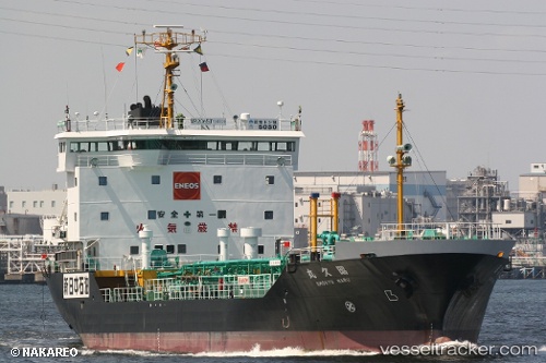
 Shokyu Maru
Current Status
Where is the vessel?
Shokyu Maru is currently in 16 nm SW of IKATA, based on AIS data received about 103d ago.
Latest AIS update:
Current position: 33.24786° N, 132.22388° E (16 nm SW of IKATA)
Average speed (last 7 days): Loading…
Average speed (last 30 days): Loading…
Vessel profile: Shokyu Maru is a Oil Products Tanker with dimensions 91m x 16m.
This page combines live AIS, route history, probable destination signals, nearby traffic, and port activity for practical vessel monitoring.
The current position of vessel Shokyu Maru is 33.24786 lat / 132.22388 lng. Updated: 2026-01-14 03:01:46 UTCNearest reference points:
- 11 nm E of SAEKI
- 18 nm SE of HIKARI
- Near Kitsuki
Currently sailing under the flag of Japan ![]()
Details:
Live Vessel Shokyu Maru Analytics (details, animations, etc.)
Recent AIS points (UTC):
2026-01-14 03:01:46 UTC · 33.24786, 132.22388 · SOG 16.4 kn · COG 41°