 vesseltracker.com
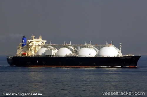
 ENERGY PROGRESS
Current Status
Where is the vessel?
ENERGY PROGRESS is currently in 21 nm NW of Burrup, based on AIS data received less than 1h ago.
Latest AIS update:
Current position: 20.33524° S, 116.52651° E (21 nm NW of Burrup)
Average speed (last 7 days): Loading…
Average speed (last 30 days): Loading…
Vessel profile: ENERGY PROGRESS is a LNG Tanker with dimensions 289m x 49m.
This page combines live AIS, route history, probable destination signals, nearby traffic, and port activity for practical vessel monitoring.
The current position of vessel ENERGY PROGRESS is -20.33524 lat / 116.52651 lng. Updated: 2026-04-28 21:58:32 UTCNearest reference points:
- 11 nm E of Port Walcot
- 116 nm NE of Mutineer
Currently sailing under the flag of Japan ![]()
ENERGY PROGRESS built in 2006 year
Deadweight:
73876 tDetails:
Live Vessel ENERGY PROGRESS Analytics (details, animations, etc.)
Recent AIS points (UTC):
2026-04-28 16:34:26 UTC · -20.33683, 116.52456 · SOG 0 kn · COG 359°2026-04-28 17:47:24 UTC · -20.33667, 116.52500 · SOG 0 kn · COG -1°
2026-04-28 19:44:25 UTC · -20.33500, 116.52500 · SOG 0 kn · COG -1°
2026-04-28 21:58:32 UTC · -20.33524, 116.52651 · SOG 0 kn · COG 283°