 vesseltracker.com
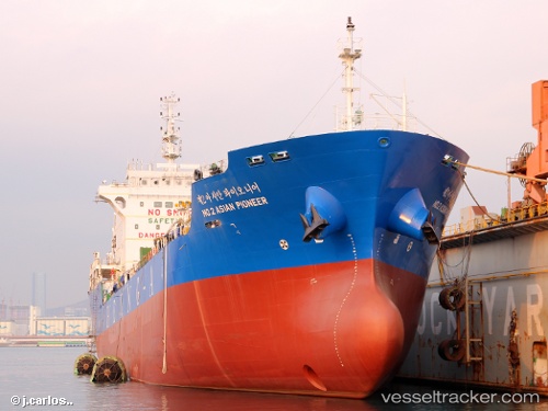
 NO. 2 ASIAN PIONEER
Current Status
Where is the vessel?
NO. 2 ASIAN PIONEER is currently in 74 nm NE of PENGERANG, based on AIS data received less than 1h ago.
Latest AIS update:
Current position: 2.30126° N, 104.92743° E (74 nm NE of PENGERANG)
Average speed (last 7 days): Loading…
Average speed (last 30 days): Loading…
Vessel profile: NO. 2 ASIAN PIONEER is a Chemical/Oil Products Tanker with dimensions 126m x 20m.
This page combines live AIS, route history, probable destination signals, nearby traffic, and port activity for practical vessel monitoring.
The current position of vessel NO. 2 ASIAN PIONEER is 2.30126 lat / 104.92743 lng. Updated: 2026-04-26 22:35:56 UTCNearest reference points:
- 64 nm NE of PENGERANG
- 80 nm SW of Terempa
- 55 nm NE of PENGERANG
Currently sailing under the flag of Korea (Republic of) ![]()
NO. 2 ASIAN PIONEER built in 2016 year
Deadweight:
12421 tDetails:
Live Vessel NO. 2 ASIAN PIONEER Analytics (details, animations, etc.)
Recent AIS points (UTC):
2026-04-26 19:19:47 UTC · 2.00899, 104.97994 · SOG 10.9 kn · COG 28°2026-04-26 19:53:17 UTC · 2.10277, 105.02464 · SOG 11.1 kn · COG 30°
2026-04-26 22:13:25 UTC · 2.35712, 104.96318 · SOG 11.9 kn · COG 256°
2026-04-26 22:35:56 UTC · 2.30126, 104.92743 · SOG 11.2 kn · COG 197°