 vesseltracker.com
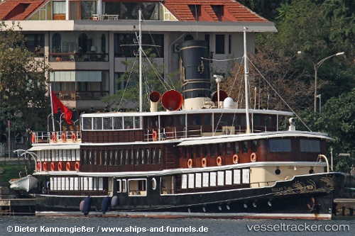
 Halas 71
Current Status
Where is the vessel?
Halas 71 is currently in Near Istinye/Istambul, based on AIS data received less than 1h ago.
Latest AIS update:
Current position: 41.11053° N, 29.05902° E (Near Istinye/Istambul)
Average speed (last 7 days): Loading…
Average speed (last 30 days): Loading…
Vessel profile: Halas 71 is a Cruise Ship with dimensions 51m x 8m.
This page combines live AIS, route history, probable destination signals, nearby traffic, and port activity for practical vessel monitoring.
The current position of vessel Halas 71 is 41.11053 lat / 29.05902 lng. Updated: 2026-05-14 07:24:41 UTCNearest reference points:
- Near Istinye/Istambul
- Near Arnavutköy/Istambul
- Near Kavacik
Currently sailing under the flag of Turkey ![]()
Halas 71 built in 1915 year
Details:
Live Vessel Halas 71 Analytics (details, animations, etc.)
Recent AIS points (UTC):
2026-05-14 05:06:42 UTC · 41.11053, 29.05904 · SOG 0 kn · COG -1°2026-05-14 06:00:41 UTC · 41.11051, 29.05905 · SOG 0 kn · COG -1°
2026-05-14 07:18:42 UTC · 41.11053, 29.05902 · SOG 0 kn · COG -1°
2026-05-14 07:24:41 UTC · 41.11053, 29.05902 · SOG 0 kn · COG -1°