 vesseltracker.com
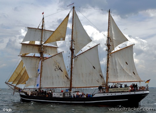
 THOR HEYERDAHL
Current Status
Where is the vessel?
THOR HEYERDAHL is currently in Near Faaborg, based on AIS data received less than 1h ago.
Latest AIS update:
Current position: 55.09381° N, 10.23987° E (Near Faaborg)
Average speed (last 7 days): Loading…
Average speed (last 30 days): Loading…
Vessel profile: THOR HEYERDAHL is a Passenger Ship with dimensions 50m x 6.53m.
This page combines live AIS, route history, probable destination signals, nearby traffic, and port activity for practical vessel monitoring.
The current position of vessel THOR HEYERDAHL is 55.09381 lat / 10.23987 lng. Updated: 2026-05-13 23:51:41 UTCNearest reference points:
- Near Faaborg
- Near Svendborg
- 10 nm E of Brodersby bei Kappeln/Schlei
Currently sailing under the flag of Germany ![]()
THOR HEYERDAHL built in 1931 year
Deadweight:
315 tDetails:
Live Vessel THOR HEYERDAHL Analytics (details, animations, etc.)
Recent AIS points (UTC):
2026-05-13 19:54:41 UTC · 55.09382, 10.23987 · SOG 0 kn · COG 285°2026-05-13 21:51:40 UTC · 55.09383, 10.23986 · SOG 0 kn · COG 286°
2026-05-13 22:57:40 UTC · 55.09383, 10.23988 · SOG 0 kn · COG 283°
2026-05-13 23:51:41 UTC · 55.09381, 10.23987 · SOG 0 kn · COG 285°