 vesseltracker.com
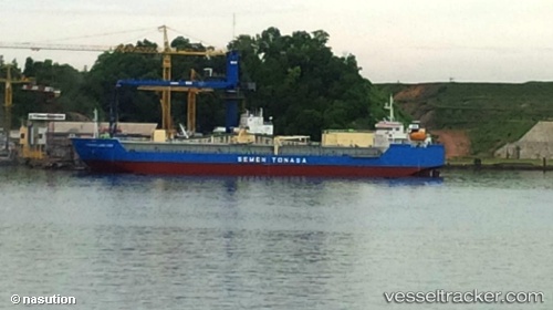
 Tonasa Line Xviii
Current Status
Where is the vessel?
Tonasa Line Xviii is currently in Near SAMARINDA, based on AIS data received about 1h ago.
Latest AIS update:
Current position: 0.55804° S, 117.17600° E (Near SAMARINDA)
Average speed (last 7 days): Loading…
Average speed (last 30 days): Loading…
Vessel profile: Tonasa Line Xviii is a Cement Carrier with dimensions 112m x 24m.
This page combines live AIS, route history, probable destination signals, nearby traffic, and port activity for practical vessel monitoring.
The current position of vessel Tonasa Line Xviii is -0.55804 lat / 117.17600 lng. Updated: 2026-04-24 11:36:06 UTCNearest reference points:
- Near SAMARINDA
- 11 nm E of SAMARINDA
- Near Handil
Currently sailing under the flag of Indonesia ![]()
Details:
Live Vessel Tonasa Line Xviii Analytics (details, animations, etc.)
Recent AIS points (UTC):
2026-04-24 07:48:04 UTC · -0.55803, 117.17601 · SOG 0 kn · COG -1°2026-04-24 09:48:04 UTC · -0.55805, 117.17601 · SOG 0 kn · COG -1°
2026-04-24 10:18:05 UTC · -0.55806, 117.17601 · SOG 0 kn · COG -1°
2026-04-24 11:36:06 UTC · -0.55804, 117.17600 · SOG 0 kn · COG -1°