 vesseltracker.com
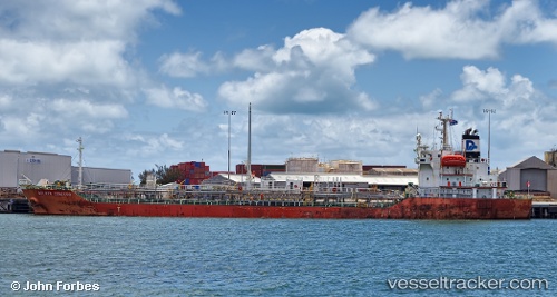
 CONCORD
Current Status
Where is the vessel?
CONCORD is currently in 76 nm N of Tanjung Pandan, based on AIS data received about 1h ago.
Latest AIS update:
Current position: 1.50167° S, 107.85333° E (76 nm N of Tanjung Pandan)
Average speed (last 7 days): Loading…
Average speed (last 30 days): Loading…
Vessel profile: CONCORD is a Chemical/Oil Products Tanker with dimensions 112m x 19m.
This page combines live AIS, route history, probable destination signals, nearby traffic, and port activity for practical vessel monitoring.
The current position of vessel CONCORD is -1.50167 lat / 107.85333 lng. Updated: 2026-05-16 05:56:16 UTCNearest reference points:
- 74 nm N of Belitung
- 81 nm N of Belitung
- 53 nm NE of Tanjung Pandan
Currently sailing under the flag of Indonesia ![]()
CONCORD built in 2004 year
Deadweight:
8578 tDetails:
Live Vessel CONCORD Analytics (details, animations, etc.)
Recent AIS points (UTC):
2026-05-16 02:15:58 UTC · -1.03500, 107.33500 · SOG 11 kn · COG -1°2026-05-16 03:25:24 UTC · -1.18167, 107.49833 · SOG 11 kn · COG -1°
2026-05-16 04:40:52 UTC · -1.33833, 107.67667 · SOG 11 kn · COG -1°
2026-05-16 05:56:16 UTC · -1.50167, 107.85333 · SOG 11 kn · COG -1°