 vesseltracker.com
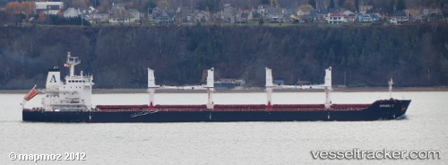
 Amanda C
Current Status
Where is the vessel?
Amanda C is currently in Near Kirikiri, based on AIS data received about 1h ago.
Latest AIS update:
Current position: 6.35703° N, 3.30145° E (Near Kirikiri)
Average speed (last 7 days): Loading…
Average speed (last 30 days): Loading…
Vessel profile: Amanda C is a Bulk Carrier with dimensions 180m x 30m.
This page combines live AIS, route history, probable destination signals, nearby traffic, and port activity for practical vessel monitoring.
The current position of vessel Amanda C is 6.35703 lat / 3.30145 lng. Updated: 2026-04-24 07:37:11 UTCNearest reference points:
- Near Kirikiri
- Near Apapa
- Near Lagos
Currently sailing under the flag of Marshall Is ![]()
Amanda C built in 2012 year
Deadweight:
34449 tDetails:
Live Vessel Amanda C Analytics (details, animations, etc.)
Recent AIS points (UTC):
2026-04-24 04:31:07 UTC · 6.35673, 3.30182 · SOG 0.3 kn · COG 218°2026-04-24 05:58:05 UTC · 6.35680, 3.30174 · SOG 0.3 kn · COG 219°
2026-04-24 07:01:05 UTC · 6.35696, 3.30155 · SOG 0.1 kn · COG 211°
2026-04-24 07:37:11 UTC · 6.35703, 3.30145 · SOG 0.3 kn · COG 205°