 vesseltracker.com
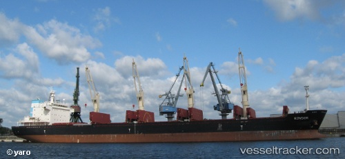
 Giorgos B
Current Status
Where is the vessel?
Giorgos B is currently in Near Al Jubayl, based on AIS data received about 61d ago.
Latest AIS update:
Current position: 27.06311° N, 49.73112° E (Near Al Jubayl)
Average speed (last 7 days): Loading…
Average speed (last 30 days): Loading…
Vessel profile: Giorgos B is a Bulk Carrier with dimensions 180m x 28m.
This page combines live AIS, route history, probable destination signals, nearby traffic, and port activity for practical vessel monitoring.
The current position of vessel Giorgos B is 27.06311 lat / 49.73112 lng. Updated: 2026-02-23 03:59:47 UTCNearest reference points:
- Near Al Jubayl
- 13 nm NE of AL JUBAIL
- Near Al Jubayl Industrial City
Currently sailing under the flag of Marshall Is ![]()
Giorgos B built in 2010 year
Deadweight:
35315 tDetails:
Live Vessel Giorgos B Analytics (details, animations, etc.)
Recent AIS points (UTC):
2026-02-23 03:59:47 UTC · 27.06311, 49.73112 · SOG 4.2 kn · COG 235°