 vesseltracker.com
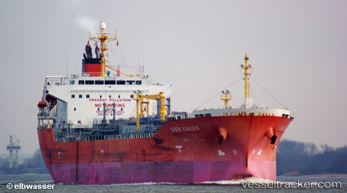
 Chem Ranger
Current Status
Where is the vessel?
Chem Ranger is currently in 353 nm S of Benahavis, based on AIS data received about 1h ago.
Latest AIS update:
Current position: 30.76577° N, 51.93488° W (353 nm S of Benahavis)
Average speed (last 7 days): Loading…
Average speed (last 30 days): Loading…
Vessel profile: Chem Ranger is a Chemical Oil Products Tanker with dimensions 159m x 27m.
This page combines live AIS, route history, probable destination signals, nearby traffic, and port activity for practical vessel monitoring.
The current position of vessel Chem Ranger is 30.76577 lat / -51.93488 lng. Updated: 2026-05-16 11:29:55 UTCNearest reference points:
- Open sea, approx. 401 nm off the nearest listed port
- Open sea, approx. 402 nm off the nearest listed port
- Open sea, approx. 403 nm off the nearest listed port
Currently sailing under the flag of Marshall Is ![]()
Chem Ranger built in 2010 year
Deadweight:
26198 tDetails:
Live Vessel Chem Ranger Analytics (details, animations, etc.)
Recent AIS points (UTC):
2026-05-16 08:19:33 UTC · 30.67058, -52.75120 · SOG 12.9 kn · COG 82°2026-05-16 09:43:26 UTC · 30.71288, -52.39368 · SOG 13 kn · COG 82°
2026-05-16 10:46:56 UTC · 30.74292, -52.12180 · SOG 13.6 kn · COG 83°
2026-05-16 11:29:55 UTC · 30.76577, -51.93488 · SOG 13.5 kn · COG 84°