 vesseltracker.com
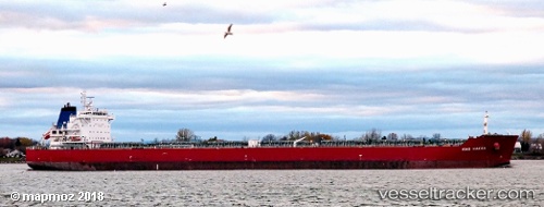
 Unity N
Current Status
Where is the vessel?
Unity N is currently in Near Port Said East, based on AIS data received about 1h ago.
Latest AIS update:
Current position: 31.17465° N, 32.34010° E (Near Port Said East)
Average speed (last 7 days): Loading…
Average speed (last 30 days): Loading…
Vessel profile: Unity N is a Bulk Carrier with dimensions 229m x 32m.
This page combines live AIS, route history, probable destination signals, nearby traffic, and port activity for practical vessel monitoring.
The current position of vessel Unity N is 31.17465 lat / 32.34010 lng. Updated: 2026-04-17 10:20:17 UTCNearest reference points:
- Near Port Said East
- Near Port Said
- 14 nm N of Port Said
Currently sailing under the flag of Marshall Is ![]()
Unity N built in 2011 year
Deadweight:
79642 tDetails:
Live Vessel Unity N Analytics (details, animations, etc.)
Recent AIS points (UTC):
2026-04-17 03:48:44 UTC · 31.17464, 32.33997 · SOG 0 kn · COG 193°2026-04-17 05:57:34 UTC · 31.17460, 32.34005 · SOG 0 kn · COG -1°
2026-04-17 07:41:18 UTC · 31.17462, 32.34007 · SOG 0 kn · COG 193°
2026-04-17 10:20:17 UTC · 31.17465, 32.34010 · SOG 0 kn · COG 193°