 vesseltracker.com
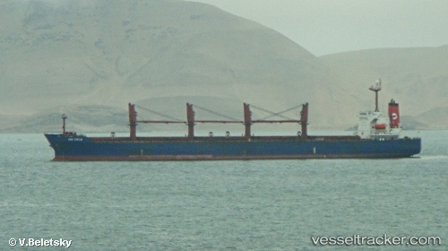
 PRINCESS BOA
Current Status
Where is the vessel?
PRINCESS BOA is currently in Near Petrolsport, based on AIS data received less than 1h ago.
Latest AIS update:
Current position: 59.88303° N, 30.20816° E (Near Petrolsport)
Average speed (last 7 days): Loading…
Average speed (last 30 days): Loading…
Vessel profile: PRINCESS BOA is a Bulk Carrier with dimensions 33m x 190m.
This page combines live AIS, route history, probable destination signals, nearby traffic, and port activity for practical vessel monitoring.
The current position of vessel PRINCESS BOA is 59.88303 lat / 30.20816 lng. Updated: 2026-05-15 00:00:13 UTCNearest reference points:
- Near Petrolsport
- Near Vassilevsky Ostrov/St Petersburg
- Near Sankt-Peterburg
Currently sailing under the flag of Marshall Islands ![]()
PRINCESS BOA built in 2003 year
Deadweight:
50337 tDetails:
Live Vessel PRINCESS BOA Analytics (details, animations, etc.)
Recent AIS points (UTC):
2026-05-14 19:35:52 UTC · 59.88167, 30.20833 · SOG 0 kn · COG -1°2026-05-14 19:35:52 UTC · 59.88167, 30.20833 · SOG 0 kn · COG -1°
2026-05-14 22:16:21 UTC · 59.88287, 30.20816 · SOG 3.4 kn · COG 317°
2026-05-15 00:00:13 UTC · 59.88303, 30.20816 · SOG 1.7 kn · COG 317°