 vesseltracker.com
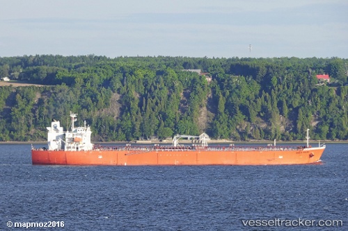
 ATAHUALPA
Current Status
Where is the vessel?
ATAHUALPA is currently in 218 nm SW of NASSIT, based on AIS data received about 1h ago.
Latest AIS update:
Current position: 6.55055° N, 16.33866° W (218 nm SW of NASSIT)
Average speed (last 7 days): Loading…
Average speed (last 30 days): Loading…
Vessel profile: ATAHUALPA is a Oil Products Tanker with dimensions 180m x 32m.
This page combines live AIS, route history, probable destination signals, nearby traffic, and port activity for practical vessel monitoring.
The current position of vessel ATAHUALPA is 6.55055 lat / -16.33866 lng. Updated: 2026-05-15 19:55:18 UTCNearest reference points:
- 79 nm SW of Conakry
- Open sea, approx. 400 nm off the nearest listed port
- Open sea, approx. 407 nm off the nearest listed port
Currently sailing under the flag of Marshall Islands ![]()
ATAHUALPA built in 2010 year
Deadweight:
46549 tDetails:
Live Vessel ATAHUALPA Analytics (details, animations, etc.)
Recent AIS points (UTC):
2026-05-15 16:32:59 UTC · 6.52647, -16.11782 · SOG 11.4 kn · COG 279°2026-05-15 17:29:09 UTC · 6.55028, -16.29568 · SOG 11.5 kn · COG 282°
2026-05-15 19:18:29 UTC · 6.55690, -16.34027 · SOG 0.4 kn · COG 265°
2026-05-15 19:55:18 UTC · 6.55055, -16.33866 · SOG 0.2 kn · COG 249°