 vesseltracker.com
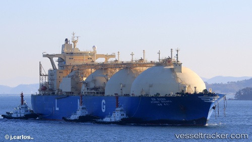
 HYUNDAI OCEANPIA
Current Status
Where is the vessel?
HYUNDAI OCEANPIA is currently in 31 nm NE of HOSAN, based on AIS data received about 22h ago.
Latest AIS update:
Current position: 37.37994° N, 129.95554° E (31 nm NE of HOSAN)
Average speed (last 7 days): Loading…
Average speed (last 30 days): Loading…
Vessel profile: HYUNDAI OCEANPIA is a LNG Tanker with dimensions 288m x 48m.
This page combines live AIS, route history, probable destination signals, nearby traffic, and port activity for practical vessel monitoring.
The current position of vessel HYUNDAI OCEANPIA is 37.37994 lat / 129.95554 lng. Updated: 2026-05-13 22:49:01 UTCNearest reference points:
- 16 nm N of Yeongyang-gun
- Near DONGHAE
- 23 nm SE of Yeongyang-gun
Currently sailing under the flag of Marshall Islands ![]()
HYUNDAI OCEANPIA built in 2000 year
Deadweight:
77512 tDetails:
Live Vessel HYUNDAI OCEANPIA Analytics (details, animations, etc.)
Recent AIS points (UTC):
2026-05-13 22:49:01 UTC · 37.37994, 129.95554 · SOG 14 kn · COG 195°2026-05-13 22:49:01 UTC · 37.37994, 129.95554 · SOG 14 kn · COG 195°
2026-05-13 22:49:01 UTC · 37.37994, 129.95554 · SOG 14 kn · COG 195°
2026-05-13 22:49:01 UTC · 37.37994, 129.95554 · SOG 14 kn · COG 195°