 vesseltracker.com
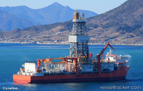
 WEST AURIGA
Current Status
Where is the vessel?
WEST AURIGA is currently in Near Cardedu, based on AIS data received about 12d ago.
Latest AIS update:
Current position: 39.71123° N, 9.70735° E (Near Cardedu)
Average speed (last 7 days): Loading…
Average speed (last 30 days): Loading…
Vessel profile: WEST AURIGA is a Drilling Ship with dimensions 42m x 227m.
This page combines live AIS, route history, probable destination signals, nearby traffic, and port activity for practical vessel monitoring.
The current position of vessel WEST AURIGA is 39.71123 lat / 9.70735 lng. Updated: 2026-04-17 14:33:00 UTCNearest reference points:
- Near Cagliari
- Near SARROCH
- Near Olbia
Currently sailing under the flag of Marshall Islands ![]()
WEST AURIGA built in 2013 year
Deadweight:
60554 tDetails:
Live Vessel WEST AURIGA Analytics (details, animations, etc.)
Recent AIS points (UTC):
2026-04-17 14:33:00 UTC · 39.71123, 9.70735 · SOG 23.3 kn · COG 214°2026-04-17 14:33:00 UTC · 39.71123, 9.70735 · SOG 23.3 kn · COG 214°
2026-04-17 14:33:00 UTC · 39.71123, 9.70735 · SOG 23.3 kn · COG 214°