 vesseltracker.com
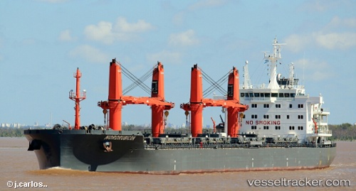
 TOMINI BORA
Current Status
Where is the vessel?
TOMINI BORA is currently in Near Hiep Phuoc Port, based on AIS data received about 12d ago.
Latest AIS update:
Current position: 10.59636° N, 106.78216° E (Near Hiep Phuoc Port)
Average speed (last 7 days): Loading…
Average speed (last 30 days): Loading…
Vessel profile: TOMINI BORA is a Bulk Carrier with dimensions 190m x 28m.
This page combines live AIS, route history, probable destination signals, nearby traffic, and port activity for practical vessel monitoring.
The current position of vessel TOMINI BORA is 10.59636 lat / 106.78216 lng. Updated: 2026-05-03 01:40:14 UTCNearest reference points:
- Near Nha Be
- Near Cat Lai Oil Port
- Near Saigon Petro Oil Terminal
Currently sailing under the flag of Marshall Islands ![]()
TOMINI BORA built in 2016 year
Deadweight:
37985 tDetails:
Live Vessel TOMINI BORA Analytics (details, animations, etc.)
Recent AIS points (UTC):
2026-05-03 01:22:29 UTC · 10.64315, 106.76135 · SOG 9.5 kn · COG 110°2026-05-03 01:40:14 UTC · 10.59636, 106.78216 · SOG 12 kn · COG 158°
2026-05-03 01:40:14 UTC · 10.59636, 106.78216 · SOG 12 kn · COG 158°
2026-05-03 01:40:14 UTC · 10.59636, 106.78216 · SOG 12 kn · COG 158°
2026-05-03 01:40:14 UTC · 10.59636, 106.78216 · SOG 12 kn · COG 158°